Dominion Atlantic Railway Digital Preservation Initiative - Wiki
Use of this site is subject to our Terms & Conditions.
Difference between revisions of "Bridgetown Bridge"
Dan conlin (talk | contribs) (1920 flood) |
Dan conlin (talk | contribs) (→Bridgetown Bridge: new use, "iconic bridge") |
||
| Line 2: | Line 2: | ||
Mile 44.47 on the [[:Category:Subdivision Kentville|Kentville Subdivision]], just east of the [[Bridgetown Station]] | Mile 44.47 on the [[:Category:Subdivision Kentville|Kentville Subdivision]], just east of the [[Bridgetown Station]] | ||
| − | The first railway crossing at [[Bridgetown]] over the Annapolis River was completed in 1869 and was described by W. W. Clarke as a covered railway bridge.<ref>[[W.W. Clarke]], [[Clarke's History of the Earliest Railways in Nova Scotia]], page 38.</ref> It was replaced by an iron truss bridge in 1881.<ref>Elizabeth Ruggles Coward, ''Bridgetown, Nova Scoita: its History Until 1900'', Kentville Publishing, 1955, page 229.</ref> The final bridge was a 155-foot long steel through truss bridge.<ref>[[1969-MemoOfGenInfo|DAR Memorandum of General Information, page 13]]</ref> It narrowly survived a major flood and ice jam in 1920 that took out the town's road bridge and washed away tracks and the roadbed either side of the bridge.<ref>"The Flood in the Annapolis Valley", ''Weekly Monitor'', March 17, 1920, page 1</ref> | + | The first railway crossing at [[Bridgetown]] over the Annapolis River was completed in 1869 and was described by W. W. Clarke as a covered railway bridge.<ref>[[W.W. Clarke]], [[Clarke's History of the Earliest Railways in Nova Scotia]], page 38.</ref> It was replaced by an iron truss bridge in 1881.<ref>Elizabeth Ruggles Coward, ''Bridgetown, Nova Scoita: its History Until 1900'', Kentville Publishing, 1955, page 229.</ref> The final bridge was a 155-foot long steel through truss bridge.<ref>[[1969-MemoOfGenInfo|DAR Memorandum of General Information, page 13]]</ref> It narrowly survived a major flood and ice jam in 1920 that took out the town's road bridge and washed away tracks and the roadbed either side of the bridge.<ref>"The Flood in the Annapolis Valley", ''Weekly Monitor'', March 17, 1920, page 1</ref> The last train crossed in 1990 when the [[:Category:Subdivision Kentville|Kentville Subdivision]] was abandoned west of [[Coldbrook]]. However the bridge was redecked for recreational use and is promoted as one of "two iconic bridges" on the Harvest Moon recreational trailway.<ref>[https://www.novascotia.com/see-do/trails/harvest-moon-trailway/7648 "Harvest Moon Trailway", ''Discover Nova Scotia''.]</ref> |
==Gallery== | ==Gallery== | ||
Revision as of 20:50, 27 March 2021
Bridgetown Bridge
Mile 44.47 on the Kentville Subdivision, just east of the Bridgetown Station
The first railway crossing at Bridgetown over the Annapolis River was completed in 1869 and was described by W. W. Clarke as a covered railway bridge.[1] It was replaced by an iron truss bridge in 1881.[2] The final bridge was a 155-foot long steel through truss bridge.[3] It narrowly survived a major flood and ice jam in 1920 that took out the town's road bridge and washed away tracks and the roadbed either side of the bridge.[4] The last train crossed in 1990 when the Kentville Subdivision was abandoned west of Coldbrook. However the bridge was redecked for recreational use and is promoted as one of "two iconic bridges" on the Harvest Moon recreational trailway.[5]
Gallery
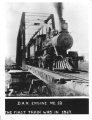
No. 18 at the bridge, Bridgetown.
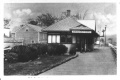
Bridgetown Station with the Bridgetown Bridge in background, circa 1920.
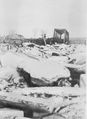
The Bridgetown Railway Bridge during the March 14, 1920 ice jam and flood.
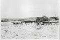
The Bridgetown road bridge collapses during ice jam and flood with the Railway Bridge in distance with the Annapolis Valley Cider plant on left, Mar. 15, 1920.
DAR work crew arrives with two platform ballast gondolas on the Bridgetown Railway Bridge after the Mar. 14, 1920 ice jam.
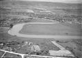
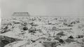
Aerial view of Bridgetown, apple warehouses at upper left, DAR bridge at centre. July, 1931.

The Bridgetown Bridge just east of the station and facing east on August 30, 2011.

A close look at the Bridgetown Bridge on August 30, 2011.


.jpg)
.jpg)
References
- ↑ W.W. Clarke, Clarke's History of the Earliest Railways in Nova Scotia, page 38.
- ↑ Elizabeth Ruggles Coward, Bridgetown, Nova Scoita: its History Until 1900, Kentville Publishing, 1955, page 229.
- ↑ DAR Memorandum of General Information, page 13
- ↑ "The Flood in the Annapolis Valley", Weekly Monitor, March 17, 1920, page 1
- ↑ "Harvest Moon Trailway", Discover Nova Scotia.