Dominion Atlantic Railway Digital Preservation Initiative - Wiki
Use of this site is subject to our Terms & Conditions.
Difference between revisions of "Halfway River Bridge"
Dan conlin (talk | contribs) (→Gallery: image) |
Dan Conlin (talk | contribs) (→Gallery: image) |
||
| (26 intermediate revisions by 3 users not shown) | |||
| Line 1: | Line 1: | ||
| − | ==Halfway River Bridge== | + | ==Halfway River Bridge/Hantsport Aboiteau== |
Mile 37.17 on the [[:Category:Subdivision Halifax|Halifax Subdivision]] | Mile 37.17 on the [[:Category:Subdivision Halifax|Halifax Subdivision]] | ||
| − | + | [[File:9365 HANTSPORT NS 1971-08 BILL LINLEYmedres.jpg|thumb|400px|right|DAR work crews repair the Hantsport Aboiteau, August 1971, photographed by Bill Linley.]] | |
| − | + | Located just east of [[Hantsport]], the bridge crossed the Halfway River (so named because in early times it marked the halfway point between [[Grand Pre]] and [[Windsor]]) where it meets the larger Avon River.<ref>[https://novascotia.ca/archives/places/page.asp?ID=278 C. Bruce Fergusson, "Hantsport"], ''Place-Names and Places of Nova Scotia'' Nova Scotia Archives (1967), page 278.</ref> The Halfway River is small, but it has a deep tidal estuary surrounded by wide tidal marshes where it is crossed by the DAR. This crossing required regular upgrades and repair throughout the history of the DAR. | |
| − | The wooden bridge was replaced by a causeway with an aboiteau in 1879.<ref>Allen B. Robertson, ''Tide and Timber: Hantsport Nova Scotia 1795-1995'', Lancelot Press, 1996, p. | + | The river was first bridged by the DAR in 1869 with a 1,800 foot trestle and a covered wooden truss bridge.<ref>[[W.W. Clarke]], [[Clarke's History of the Earliest Railways in Nova Scotia]], page 38.</ref> By 1873, an engineer's report indicated that the trestle was 640 feet long (32 trestle spans, each each 20 feet long) and the bridge was a 150-foot long wooden truss bridge. The report by engineer Alexander MacNab noted that the main span was weak and needed a pier in the middle and that many of the pile trestles were gradually being replaced by trestle bents.<ref>[https://archive.org/stream/cihm_25953#page/n11 Windsor and Annapolis Railway, Report of Alexander MacNab, C. E., November 1, 1873, page 7.]</ref> The wooden bridge was replaced by a causeway with an aboiteau in 1879.<ref>Allen B. Robertson, ''Tide and Timber: Hantsport Nova Scotia 1795-1995'', Lancelot Press, 1996, page 71</ref> The aboiteau was rebuilt in 1914-1915.<ref>[[Canadian Railway and Marine World - 1914-11 - Extensive Improvements on the Dominion Atlantic Railway|Extensive Improvements on the Dominion Atlantic Railway.” ''CANADIAN RAILWAY AND MARINE WORLD,'' November 1914, 490.|Extensive Improvements on the Dominion Atlantic Railway.” ''CANADIAN RAILWAY AND MARINE WORLD,'' November 1914, p. 490.]]</ref> |
| − | By 1969, the | + | By 1969, most of the trestle approach had been filled and converted to an embankment leaving a 40-foot-long pile trestle over a spillway on the east side of a causeway crossing the Halfway River over an aboiteau with three 60-inch corrugated metal pipes.<ref>[[1969-MemoOfGenInfo|''Memorandum of General Information on the Dominion Atlantic Railway'', Feb. 17, 1969,]] page 4, Dominion Atlantic Railway, Library and Archives Canada HE2810 D7 D7 fol</ref> The roadbed and aboiteau was washed out by heavy flood waters on August 16, 1971 <ref>[https://www.facebook.com/HantsportAreaHistoricalSociety/posts/pfbid02dm6NvWdm7cShQTCFNThmS43Pcpj4NqWTJfHcgQY8u3bt7L7pnDSEd2DtCFjWE6bql Hantsport and Area Historical Society Facebook Post Aug. 16, 2023]</ref> but the line and aboiteau was was quickly repaired by DAR crews who installed new culvert pipes.<ref>[[:Category:Bill Linley|Bill Linley]], [[Canadian Pacific in Color Volume 1: Eastern Lines]], page 14.</ref> |
| − | + | The railway ceased to be used in 2011. The causeway slowly began to erode and the aboiteau gates ceased functioning. Erosion increased dramatically in September 2017 and a large washout occurred in the causeway, leaving the rails hanging in mid-air and exposing the pile trestle work of older versions of the bridge.<ref>[http://www.kingscountynews.ca/news/hantsports-halfway-river-aboiteau-failing-residents-concerned-about-bridge-integrity-176524/ Carole Morris-Underhill, "Hantsport's Halfway River aboiteau failing, residents concerned about bridge integrity", ''Kings County Advertiser/Register'', January 11, 2018.]</ref> The [[Windsor and Hantsport Railway]] put up barricades and removed the hanging rails on February 7, 2018,<ref>[http://www.kingscountynews.ca/news/hantsports-failed-aboiteau-not-only-railways-problem-to-fix-owner-184748/ Carole Morris-Underhill, "Hantsport's failed aboiteau not only railway's problem to fix: owner, ''Kings County Advertiser/Register'', February 9, 2018]</ref> but the washout grew leading to extensive tidal flooding of the formerly protected Halfway River Valley which raised fears about erosion and flooding of roads and power lines. The flooding has led to a dispute between the Province of Nova Scotia and the Windsor and Hantsport Railway over who owns the aboiteau and who bears the responsibility for the washout.<ref>[https://www.kingscountynews.ca/opinion/letter-railway-owner-weighs-in-on-hantsport-aboiteau-issue-240056/ "LETTER: Railway owner weighs in on Hantsport aboiteau issue", ''The Register/Advertiser'', Sept. 10, 2018]</ref> After the site the site was documented by arachaeologists, the province rebuilt the aboiteau in the fall of 2019 and is suing the Windsor and Hantsport Railway for the cost.<ref>[https://www.cbc.ca/news/canada/nova-scotia/hantsport-aboiteau-construction-flooding-climate-change-1.5337731 Michael Gorman, "Upgrades to former Hantsport aboiteau about a month from completion", ''CBC News'', Oct 29, 2019]</ref> | |
| − | |||
| − | The railway ceased to be used in 2011. The causeway slowly began to erode and the aboiteau gates ceased functioning. Erosion increased dramatically in September 2017 and a large washout occurred in the causeway, leaving the rails hanging in mid-air and exposing the pile trestle work of older versions of the bridge.<ref>[http://www.kingscountynews.ca/news/hantsports-halfway-river-aboiteau-failing-residents-concerned-about-bridge-integrity-176524/ Carole Morris-Underhill, "Hantsport's Halfway River aboiteau failing, residents concerned about bridge integrity", ''Kings County Advertiser/Register'', January 11, 2018.]</ref> The [[Windsor and Hantsport Railway]] removed the hanging rails | ||
==Gallery== | ==Gallery== | ||
<gallery> | <gallery> | ||
Image:Halfway River Bridge construction.jpg|Construction work at the [[Halfway River Bridge]] in [[Hantsport]], with the town in the background, date unknown. | Image:Halfway River Bridge construction.jpg|Construction work at the [[Halfway River Bridge]] in [[Hantsport]], with the town in the background, date unknown. | ||
| − | Image:Bluenose hantsport.jpg|Flying Bluenose at [[Hantsport]] crossing the [[Halfway River Bridge]], possibly with | + | Image:Bluenose hantsport.jpg|The [[Flying Bluenose]] at [[Hantsport]] crossing the [[Halfway River Bridge]], with coach [[DAR000027|No. 27]] and possibly baggage car [[DAR000046|No. 46]] and [[DAR0024|Engine 24]], 1911. |
| − | File:9365 HANTSPORT NS 1971-08 BILL | + | File:Kalkman106.jpg|Coloured postcard showing the [[Flying Bluenose]] leaving [[Hantsport]] crossing the [[Halfway River Bridge]] with passenger car [[DAR000027|No.27 "IRIS"]] and possibly baggage car [[DAR000046|No. 46]] and locomotive [[DAR0024|No. 24]], 1911. |
| − | File: | + | File:HA-38.60 Hantsport Track Chart.JPG|Track schematic for [[Hantsport]], 1918s, including the gypsum loading spurs, the Minas Basin Pulp spurs, the [[Hantsport Railyard]] and the [[Halfway River Bridge|Halfway River Bridge and Aboiteau]]. |
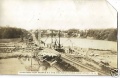
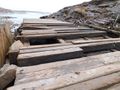
| + | File:9365 HANTSPORT NS 1971-08 BILL LINLEYmedres.jpg|[[CPR8133|No. 8133]] and ballast cars repairing washout at the [[Halfway River Bridge]] at [[Hantsport]], CKF paper plant in background, August 1971. | ||
| + | File:CEMR 4012&4011 Gypsum train Hantsport 17 August 2007.jpg|[[:Category:Windsor and Hantsport Railway|Windsor and Hantsport]] leased locomotives CEMR 4012 4011 haul a gypsum train nearing across the [[Halfway River Bridge]] at [[Hantsport]], August 17, 2007. | ||
| + | </gallery> | ||
| + | |||
| + | ==2017 Washout== | ||
| + | <gallery> | ||
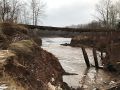
| + | File:Skelton1.jpg|[[Halfway River Bridge]] washout at [[Hantsport]] with DAR tracks hanging in midair over the eroding causeway over the former aboiteau, December 2017. | ||
| + | File:Skelton2.jpg|[[Halfway River Bridge]] washout at [[Hantsport]] with DAR tracks hanging over the former aboiteau and dyke remains, December 2017. | ||
File:SkeltonApril28.2018.31398156 10214573770030839 98142811622211584 n.jpg|[[Halfway River Bridge]] washout at [[Hantsport]], with collapsed aboiteau remnants of older bridge structure, April 28, 2018. | File:SkeltonApril28.2018.31398156 10214573770030839 98142811622211584 n.jpg|[[Halfway River Bridge]] washout at [[Hantsport]], with collapsed aboiteau remnants of older bridge structure, April 28, 2018. | ||
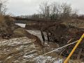
File:IMG 6594.JPG|[[Halfway River Bridge]] looking west at [[Hantsport]], close up of bridgework remains, Aug. 13, 2018 | File:IMG 6594.JPG|[[Halfway River Bridge]] looking west at [[Hantsport]], close up of bridgework remains, Aug. 13, 2018 | ||
IMG 6587.JPG|[[Halfway River Bridge]] washout at [[Hantsport]] and the bridge remains, August 13, 2018. | IMG 6587.JPG|[[Halfway River Bridge]] washout at [[Hantsport]] and the bridge remains, August 13, 2018. | ||
HalfwayBridge15.09.18.jpg|[[Halfway River Bridge]] at [[Hantsport]], east side with wash out and piles from older bridges, with the CKF paper plant in background, Sept. 15, 2018. | HalfwayBridge15.09.18.jpg|[[Halfway River Bridge]] at [[Hantsport]], east side with wash out and piles from older bridges, with the CKF paper plant in background, Sept. 15, 2018. | ||
| + | </gallery> | ||
| + | |||
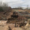
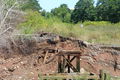
| + | ==2019 Archaeology== | ||
| + | Description of the aboiteau site by [[:Category:Laura de Boer|Laura de Boer]], archaeologist at Davis MacIntyre & Associates: | ||
| + | |||
| + | The structure of the existing aboiteau appears to feature two broad stone-filled wood boxes (wooden gabions) on either side of the aboiteau entrance on the west or upstream side, followed by three additional roughly square stone-filled boxes on either side of the aboiteau just downstream, and also including some brush on the north side. Nearly a dozen steel rails were also recovered from this area, some of which were marked “DOMINION”, “MACKIE”, and “D I & S Co”, indicating they were made in Sydney, Cape Breton. At least four of the rails were also deliberately bent at either end, pointing to their reuse as some element of structure or erosion control for the aboiteau. One of these rails was covered in grey "fat clay," which had preserved traces of sawdust against the steel. | ||
| + | |||
| + | The middle of the aboiteau, being formerly in the middle of the embankment, appears to have needed no ballast to either side to hold it in place. Some additional wooden boxes of stone visible nearer to the eastern mouth of the aboiteau suggest that the structure may have been originally symmetrical, being reinforced and held in place on either end with heavy wooden-planked boxes of stone. The sluice itself is a heavy wooden culvert with two internal partitions, creating three passages for the water, decked on top with two layers of thick wooden planks. Some of the side timbers feature roman numerals presumably designed to guide the proper placement of the pre-constructed aboiteau during installation. Precise measurements were not taken and the original position and nature of the flap for the sluice gate is no longer clear (at least without risking exploration in close proximity to the fast-moving tides). | ||
| + | |||
| + | The vertical wooden piles on either side of the aboiteau structure are almost certainly the original 1869 wooden trestle bases for the rail bridge. It was necessary to cut or break the trestles off during the course of the archaeological monitoring, as attempts to pull them free of the grey clay proved impossible even when applying 40 metric tonnes of pulling force using the on-site crane, both directly and with a vibrator unit. Elements of the rock-filled wooden boxes also had to be dug out, as pulling them out resulted in the boards breaking and the bottom ends being held in place by the suction of the fat clay. | ||
| + | |||
| + | <gallery> | ||
| + | File:HalfwayAboiteauSketch.png|Archaeological drawing of the aboiteau and trestle remains in the washed out [[Halfway River Bridge]] at [[Hantsport]], March 2019. | ||
| + | File:DeBoer DSCN1530.jpeg|Aboiteau site at the [[Halfway River Bridge]], [[Hantsport]], March 2019. | ||
| + | File:DeBoer DSCN1553.jpeg|Aboiteau site with recycled rail component at the [[Halfway River Bridge]], [[Hantsport]], March 2019. | ||
| + | File:DeBoer DSCN1571.jpeg|Recycled rail component at the [[Halfway River Bridge]], [[Hantsport]], March 2019. | ||
| + | File:DeBoer DSCN1566.jpeg|Older lightweight rails recycled in the structure of the [[Halfway River Bridge]], [[Hantsport]], March 2019. | ||
| + | File:DeBoer DSCN1591.jpeg|Aboiteau at the [[Halfway River Bridge]] with stone-filled wood boxes (gabions) at [[Hantsport]], March 2019. | ||
| + | File:DeBoer DSCN1592.jpeg|Deck of the aboiteau at the [[Halfway River Bridge]], [[Hantsport]], March 2019. | ||
</gallery> | </gallery> | ||
Latest revision as of 20:06, 17 July 2024
Halfway River Bridge/Hantsport Aboiteau
Mile 37.17 on the Halifax Subdivision

Located just east of Hantsport, the bridge crossed the Halfway River (so named because in early times it marked the halfway point between Grand Pre and Windsor) where it meets the larger Avon River.[1] The Halfway River is small, but it has a deep tidal estuary surrounded by wide tidal marshes where it is crossed by the DAR. This crossing required regular upgrades and repair throughout the history of the DAR.
The river was first bridged by the DAR in 1869 with a 1,800 foot trestle and a covered wooden truss bridge.[2] By 1873, an engineer's report indicated that the trestle was 640 feet long (32 trestle spans, each each 20 feet long) and the bridge was a 150-foot long wooden truss bridge. The report by engineer Alexander MacNab noted that the main span was weak and needed a pier in the middle and that many of the pile trestles were gradually being replaced by trestle bents.[3] The wooden bridge was replaced by a causeway with an aboiteau in 1879.[4] The aboiteau was rebuilt in 1914-1915.[5]
By 1969, most of the trestle approach had been filled and converted to an embankment leaving a 40-foot-long pile trestle over a spillway on the east side of a causeway crossing the Halfway River over an aboiteau with three 60-inch corrugated metal pipes.[6] The roadbed and aboiteau was washed out by heavy flood waters on August 16, 1971 [7] but the line and aboiteau was was quickly repaired by DAR crews who installed new culvert pipes.[8]
The railway ceased to be used in 2011. The causeway slowly began to erode and the aboiteau gates ceased functioning. Erosion increased dramatically in September 2017 and a large washout occurred in the causeway, leaving the rails hanging in mid-air and exposing the pile trestle work of older versions of the bridge.[9] The Windsor and Hantsport Railway put up barricades and removed the hanging rails on February 7, 2018,[10] but the washout grew leading to extensive tidal flooding of the formerly protected Halfway River Valley which raised fears about erosion and flooding of roads and power lines. The flooding has led to a dispute between the Province of Nova Scotia and the Windsor and Hantsport Railway over who owns the aboiteau and who bears the responsibility for the washout.[11] After the site the site was documented by arachaeologists, the province rebuilt the aboiteau in the fall of 2019 and is suing the Windsor and Hantsport Railway for the cost.[12]
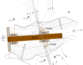
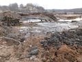
Gallery
Construction work at the Halfway River Bridge in Hantsport, with the town in the background, date unknown.
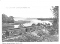
The Flying Bluenose at Hantsport crossing the Halfway River Bridge, with coach No. 27 and possibly baggage car No. 46 and Engine 24, 1911.
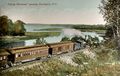
Coloured postcard showing the Flying Bluenose leaving Hantsport crossing the Halfway River Bridge with passenger car No.27 "IRIS" and possibly baggage car No. 46 and locomotive No. 24, 1911.

Track schematic for Hantsport, 1918s, including the gypsum loading spurs, the Minas Basin Pulp spurs, the Hantsport Railyard and the Halfway River Bridge and Aboiteau.

No. 8133 and ballast cars repairing washout at the Halfway River Bridge at Hantsport, CKF paper plant in background, August 1971.
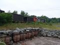
Windsor and Hantsport leased locomotives CEMR 4012 4011 haul a gypsum train nearing across the Halfway River Bridge at Hantsport, August 17, 2007.


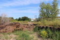
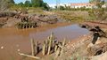
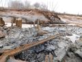
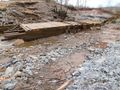
2017 Washout
Halfway River Bridge washout at Hantsport with DAR tracks hanging in midair over the eroding causeway over the former aboiteau, December 2017.
Halfway River Bridge washout at Hantsport with DAR tracks hanging over the former aboiteau and dyke remains, December 2017.
Halfway River Bridge washout at Hantsport, with collapsed aboiteau remnants of older bridge structure, April 28, 2018.
Halfway River Bridge looking west at Hantsport, close up of bridgework remains, Aug. 13, 2018
Halfway River Bridge washout at Hantsport and the bridge remains, August 13, 2018.
Halfway River Bridge at Hantsport, east side with wash out and piles from older bridges, with the CKF paper plant in background, Sept. 15, 2018.


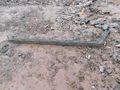
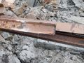
2019 Archaeology
Description of the aboiteau site by Laura de Boer, archaeologist at Davis MacIntyre & Associates:
The structure of the existing aboiteau appears to feature two broad stone-filled wood boxes (wooden gabions) on either side of the aboiteau entrance on the west or upstream side, followed by three additional roughly square stone-filled boxes on either side of the aboiteau just downstream, and also including some brush on the north side. Nearly a dozen steel rails were also recovered from this area, some of which were marked “DOMINION”, “MACKIE”, and “D I & S Co”, indicating they were made in Sydney, Cape Breton. At least four of the rails were also deliberately bent at either end, pointing to their reuse as some element of structure or erosion control for the aboiteau. One of these rails was covered in grey "fat clay," which had preserved traces of sawdust against the steel.
The middle of the aboiteau, being formerly in the middle of the embankment, appears to have needed no ballast to either side to hold it in place. Some additional wooden boxes of stone visible nearer to the eastern mouth of the aboiteau suggest that the structure may have been originally symmetrical, being reinforced and held in place on either end with heavy wooden-planked boxes of stone. The sluice itself is a heavy wooden culvert with two internal partitions, creating three passages for the water, decked on top with two layers of thick wooden planks. Some of the side timbers feature roman numerals presumably designed to guide the proper placement of the pre-constructed aboiteau during installation. Precise measurements were not taken and the original position and nature of the flap for the sluice gate is no longer clear (at least without risking exploration in close proximity to the fast-moving tides).
The vertical wooden piles on either side of the aboiteau structure are almost certainly the original 1869 wooden trestle bases for the rail bridge. It was necessary to cut or break the trestles off during the course of the archaeological monitoring, as attempts to pull them free of the grey clay proved impossible even when applying 40 metric tonnes of pulling force using the on-site crane, both directly and with a vibrator unit. Elements of the rock-filled wooden boxes also had to be dug out, as pulling them out resulted in the boards breaking and the bottom ends being held in place by the suction of the fat clay.
Archaeological drawing of the aboiteau and trestle remains in the washed out Halfway River Bridge at Hantsport, March 2019.
Aboiteau site at the Halfway River Bridge, Hantsport, March 2019.
Aboiteau site with recycled rail component at the Halfway River Bridge, Hantsport, March 2019.
Recycled rail component at the Halfway River Bridge, Hantsport, March 2019.
Older lightweight rails recycled in the structure of the Halfway River Bridge, Hantsport, March 2019.
Aboiteau at the Halfway River Bridge with stone-filled wood boxes (gabions) at Hantsport, March 2019.
Deck of the aboiteau at the Halfway River Bridge, Hantsport, March 2019.


References
- ↑ C. Bruce Fergusson, "Hantsport", Place-Names and Places of Nova Scotia Nova Scotia Archives (1967), page 278.
- ↑ W.W. Clarke, Clarke's History of the Earliest Railways in Nova Scotia, page 38.
- ↑ Windsor and Annapolis Railway, Report of Alexander MacNab, C. E., November 1, 1873, page 7.
- ↑ Allen B. Robertson, Tide and Timber: Hantsport Nova Scotia 1795-1995, Lancelot Press, 1996, page 71
- ↑ Extensive Improvements on the Dominion Atlantic Railway.” CANADIAN RAILWAY AND MARINE WORLD, November 1914, 490.|Extensive Improvements on the Dominion Atlantic Railway.” CANADIAN RAILWAY AND MARINE WORLD, November 1914, p. 490.
- ↑ Memorandum of General Information on the Dominion Atlantic Railway, Feb. 17, 1969, page 4, Dominion Atlantic Railway, Library and Archives Canada HE2810 D7 D7 fol
- ↑ Hantsport and Area Historical Society Facebook Post Aug. 16, 2023
- ↑ Bill Linley, Canadian Pacific in Color Volume 1: Eastern Lines, page 14.
- ↑ Carole Morris-Underhill, "Hantsport's Halfway River aboiteau failing, residents concerned about bridge integrity", Kings County Advertiser/Register, January 11, 2018.
- ↑ Carole Morris-Underhill, "Hantsport's failed aboiteau not only railway's problem to fix: owner, Kings County Advertiser/Register, February 9, 2018
- ↑ "LETTER: Railway owner weighs in on Hantsport aboiteau issue", The Register/Advertiser, Sept. 10, 2018
- ↑ Michael Gorman, "Upgrades to former Hantsport aboiteau about a month from completion", CBC News, Oct 29, 2019