Dominion Atlantic Railway Digital Preservation Initiative - Wiki
Use of this site is subject to our Terms & Conditions.
Difference between revisions of "Bridgetown Bridge"
Sarah Taylor (talk | contribs) m (→Bridgetown Bridge: typo fix) |
Dan conlin (talk | contribs) (→Gallery: image) |
||
| Line 8: | Line 8: | ||
Image:Engine 18 Bridetown.jpg|[[DAR0018|No. 18]] at the bridge, [[Bridgetown]]. | Image:Engine 18 Bridetown.jpg|[[DAR0018|No. 18]] at the bridge, [[Bridgetown]]. | ||
Image:Bridgetown2.jpg|[[Bridgetown Station]] with the [[Bridgetown Bridge]] in background, circa 1920. | Image:Bridgetown2.jpg|[[Bridgetown Station]] with the [[Bridgetown Bridge]] in background, circa 1920. | ||
| + | File:Btown1.jpg|The [[Bridgetown Bridge|Bridgetown Railway Bridge]] during the March 14, 1920 ice jam and flood. | ||
File:Bridgetown Aerial.jpg|Aerial view of [[Bridgetown]], apple warehouses at upper left, [[Bridgetown Bridge|DAR bridge at centre]]. July, 1931. | File:Bridgetown Aerial.jpg|Aerial view of [[Bridgetown]], apple warehouses at upper left, [[Bridgetown Bridge|DAR bridge at centre]]. July, 1931. | ||
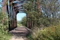
File:Bridgetown 2 (1280x853).jpg|The [[Bridgetown Bridge]] just east of the station and facing east on August 30, 2011. | File:Bridgetown 2 (1280x853).jpg|The [[Bridgetown Bridge]] just east of the station and facing east on August 30, 2011. | ||
Revision as of 19:23, 26 March 2021
Bridgetown Bridge
Mile 44.47 on the Kentville Subdivision, just east of the Bridgetown Station
The first railway crossing at Bridgetown over the Annapolis River was completed in 1869 and was described by W. W. Clarke as a covered railway bridge.[1] It was replaced by an iron truss bridge in 1881.[2] The final bridge was a 155-foot long steel through truss bridge.[3]
Gallery
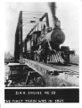
No. 18 at the bridge, Bridgetown.
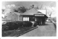
Bridgetown Station with the Bridgetown Bridge in background, circa 1920.

The Bridgetown Railway Bridge during the March 14, 1920 ice jam and flood.
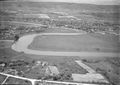
Aerial view of Bridgetown, apple warehouses at upper left, DAR bridge at centre. July, 1931.

The Bridgetown Bridge just east of the station and facing east on August 30, 2011.
A close look at the Bridgetown Bridge on August 30, 2011.


.jpg)
.jpg)
References
- ↑ W.W. Clarke, Clarke's History of the Earliest Railways in Nova Scotia, page 38.
- ↑ Elizabeth Ruggles Coward, Bridgetown, Nova Scoita: its History Until 1900, Kentville Publishing, 1955, page 229.
- ↑ DAR Memorandum of General Information, page 13