Dominion Atlantic Railway Digital Preservation Initiative - Wiki
Use of this site is subject to our Terms & Conditions.
File:CanningSpur.jpg
From DARwiki

Size of this preview: 800 × 544 pixels. Other resolutions: 320 × 218 pixels | 2,328 × 1,584 pixels.
Original file (2,328 × 1,584 pixels, file size: 618 KB, MIME type: image/jpeg)
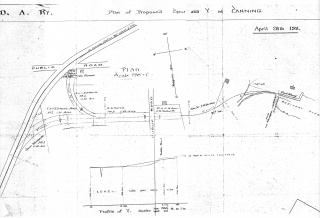
Map of the Canning Wye and Spur as designed, April 1911, with updates May 1911, from Library and Archives Canada, RG43, Vol 2787.
File history
Click on a date/time to view the file as it appeared at that time.
| Date/Time | Thumbnail | Dimensions | User | Comment | |
|---|---|---|---|---|---|
| current | 16:30, 23 March 2014 | | 2,328 × 1,584 (618 KB) | Dan conlin (talk | contribs) | Map of the Canning Wye and Spur from Library and Archives Canada, May 1911. |
You cannot overwrite this file.
File usage
The following 3 pages use this file: