Dominion Atlantic Railway Digital Preservation Initiative - Wiki
Use of this site is subject to our Terms & Conditions.
Difference between revisions of "Kentville Railyard"
Dan Conlin (talk | contribs) (→Kentville Railyard: image) |
Dan Conlin (talk | contribs) (→Railyard Views: image) |
||
| Line 51: | Line 51: | ||
File:Kalkman49.jpg|The [[Kentville Railyard]] looking east after a heavy snow with the first [[Kentville Water Tower]], undated, probably 1920s. | File:Kalkman49.jpg|The [[Kentville Railyard]] looking east after a heavy snow with the first [[Kentville Water Tower]], undated, probably 1920s. | ||
File:Kalkman014.jpg|[[Kentville Railyard]] looking west with the [[DAR000006|Coach No. 6 "Graciosa"]] on the right, circa 1935. | File:Kalkman014.jpg|[[Kentville Railyard]] looking west with the [[DAR000006|Coach No. 6 "Graciosa"]] on the right, circa 1935. | ||
| − | File:5 loco.jpg| | + | |
| + | File:5 loco.jpg|The Five Locomotive Line-up, Side View, of locomotives [[DAR2552|No. 2552]], [[DAR0999|No. 999]], [[DAR0544|No. 544]], [[DAR0032|No. 32]] and [[DAR0025|No. 25]] posed in the [[Kentville Railyard]], May 14, 1937. | ||
| + | File:Kalkman113.jpg|The Five Locomotive Line-up, Head-On View, of locomotives [[DAR2552|No. 2552]], [[DAR0999|No. 999]], [[DAR0544|No. 544]], [[DAR0032|No. 32]] and [[DAR0025|No. 25]] posed in the [[Kentville Railyard]], May 14, 1937. | ||
| + | |||
File:Canada Foods 2.jpg|[[Canada Foods Plant]] and switchstands of the [[Kentville Railyard]], circa 1948. | File:Canada Foods 2.jpg|[[Canada Foods Plant]] and switchstands of the [[Kentville Railyard]], circa 1948. | ||
File:Canada Foods 3.jpg|[[Canada Foods Plant]] and tracks of the [[Kentville Railyard]], circa 1948. | File:Canada Foods 3.jpg|[[Canada Foods Plant]] and tracks of the [[Kentville Railyard]], circa 1948. | ||
Latest revision as of 07:11, 4 August 2024
Kentville Railyard
The Kentville railyard was located between the Cornwallis River and Kentville's Main Street. It consisted of a freight yard, terminal tracks, a coach yard and industry spurs. Long a dominant feature in the town of Kentville, the yard was in operation from 1868 until 1993.
The freight yards in Kentville were located south of the the roundhouse and machine shop. The yard tracks fanned out from switches located at the level crossing of West Main Street. The yard tracks in their final form consisted of: four shunting sidings to the north of DAR the mainline, North 1, North 2, North 3 and North 4; and four shunting tracks located to the south of the mainline, South 1, South 2, South 3 and South 4. The freight yard also contained the Kentville Track Scale. A siding and lead track connected the various yard tracks.
North of the freight yard, a ladder track provided access to the terminal tracks serving the various DAR shops, such as the turntable and roundhouse, machine shop, car shop, repair shop, the Kentville Water Tower and Kentville Coaling Tower. A coach yard was located between the car shop and the station with several spurs serviced by steam lines to heat stored passenger cars. The ladder track led to the Cornwallis River Bridge and continued as the Kingsport Subdivision. Spurs serving various industries led off the yard track at various points, most significantly, the "Back Road Spur" which served multiple industries along River Street.
Evolution of the Yard
As first built by the Windsor and Annapolis Railway in 1869, the yard covered about 7 to 8 acres and had eight tracks. They were the main line; a through siding; a track for loading and discharging; a "Hospital siding" for broken cars; a "dead siding" for scrapping or storing cars; a siding into the Engine Shed and two tracks into the Car Shop.[1]
The yard was expanded in stages by filling of the meadows along the Cornwallis River.


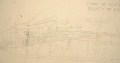
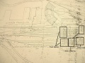
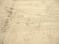
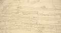
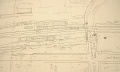
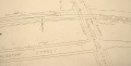
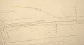
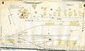
Railyard in sections
The above drawing is difficult to read but is proportionately correct and was scanned at 200 DPI. These images although not proportionally correct because they appeared photographed, not scanned, are the same map as above in sections and very readable with additional notes to explain some of the original notations on the map.
These images are just begging to be put on CAD. If anyone can help this way or advise what the proper way to set up a CAD file for land mapping is so others can do the tracing, please let us know. See this message thread on our forum: http://dardpi.ca/Forum/viewtopic.php?f=3&t=18#p49
Entire Map - low res. Same as above large map.
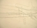
Section 1
Section 2
Section 3
Section 4
Section 5
Section 6
Section 7
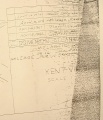
Title Block

.JPG)
.JPG)
.JPG)
.JPG)
.JPG)
.JPG)
.JPG)

Fire Insurance Maps 1921

Annotated detail of Kentville Fire Insurance Map showing the Kentville Roundhouse, Kentville Machine Shop, the old W&AR Water Tower, Engineer's Rest Bunk House and Kentville Railyard, Aug. 1921.
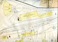
Clean detail of Kentville Fire Insurance Map showing the Kentville Roundhouse, Kentville Machine Shop, the old W&AR Water Tower, Engineer's Rest Bunk House and Kentville Railyard, Aug. 1921.
Detail of Kentville Fire Insurance Map showing the Kentville Station, Kentville Repair Shop, Kentville Ice House, railway tennis courts and the "Back Road" spur, Aug. 1921.
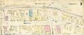
Detail Kentville Fire Insurance Map with Webster Street business including the United Fruit Companies Headquarters and the P. R. Ritcey Spur Aug. 1921.


Railyard Views
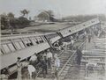
Derailment of troop train bound for Camp Aldershot in the Kentville Railyard, Sept. 9, 1913.
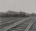
DAR No. 28 and a 4-4-0 shunting cars in the Kentville Railyard beside the P. R. Ritcey store with the Kentville Station in background, March 1916
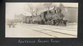
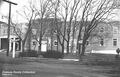
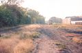
The Kentville Railyard looking east after a heavy snow with the first Kentville Water Tower, undated, probably 1920s.
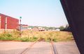
Kentville Railyard looking west with the Coach No. 6 "Graciosa" on the right, circa 1935.
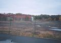
Canada Foods Plant and switchstands of the Kentville Railyard, circa 1948.
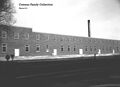
Canada Foods Plant and tracks of the Kentville Railyard, circa 1948.
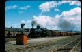
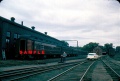
No. 2665 departs Kentville leading Train No. 95 through the Kentville Railyard. Visible is sanding tower and the roof of the Machine Shop store shed, August 1951.
Locomotive No. 2627 with Train No. 95 switching at the Kentville Railyard with the Kentville Repair Shop and Kentville Station, August 1955.
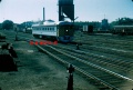
DAR Dayliner, No. 9058 or 9059 crossing Kentville Railyard to arrive at Kentville with the Kentville Coaling Tower and Kentville Water Tower in the background, 1956.
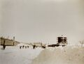
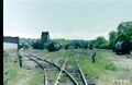
Kentville Railyard looking east from the base of the coal tower July 1958.
Kentville Railyard with inspection car, passenger car and Kentville Station in background in August of 1959.
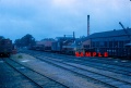
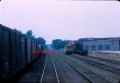
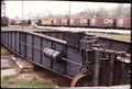
CPR diesel No. 8135 passes through the Kentville Railyard past the south side of the machine shop and past the track scale, 1961.
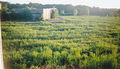
Canada Foods Plant and portions of the Kentville Railyard after the food plant fire, October 1966.
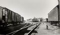
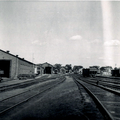
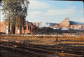
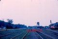
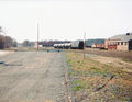
Kentville general yard view on July 21, 1967.
Kentville Railyard with left to right, the Kentville Car Shop, Kentville Repair Shop and the Kentville Station, July 21, 1967.
Kentville Railyard looking east with the Kentville Station and the Kentville Freight Shed, July 21, 1967.
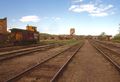
The Kentville Railyard looking west, with South yard on left, the mainline centre, north yard tracks on right and the Kentville Roundhouse, Kentville Coaling Tower and the Kentville Car Shop, 1975.
Kentville Railyard looking west, mainline at centre, freight on the south 1 yard track to right, south yard tracks and Kentville Roundhouse to right, 1975.
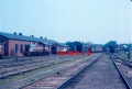
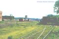
Kentville Railyard with Kentville Station to right, Feb. 14, 1976.
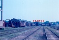
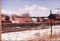
The Kentville Railyard with Coaling Tower and stored MOW equipment, circa Feb 1976.
Kentville Turntable in front of Roundhouse with Kentville Railyard in background, May 5, 1976.
Kentville Railyard, with left to right: corner of Kentville Roundhouse, CPR Van 437345, DAR scrap line, snow plows, Car Shop, Coaling Tower, Repair Shop, Kentville Station and the Kentville Track Scale, May 26, 1977.
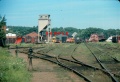
Kentville Railyard with north yard tracks to left and the mainline on right, plus the Kentville Roundhouse, the Kentville Coaling Tower, the Kentville Car Shop, the Kentville Repair Shop and the Kentville Station, 1977.
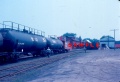
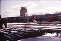
Kentville Railyard with tracks full of cars with Kentville Coaling Tower and the Kentville Track Scale, summer 1977.
Kentville Roundhouse and Kentville Railyard on March 16, 1980.
Kentville Railyard looking east with, left to right: the roundhouse, boiler plant, coal tower, car shop, repair shop, Kentville Station and the Kentville Track Scale, May 29, 1989.
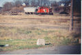
An SW1200 brings a covered hopper from the CVR Spur into the Kentville Railyard, 1990.
Final years of the Kentville Railyard with fuel cars for CFB Greenwood; a covered hopper for Steam Mill Village & MOW cars at the car shop with the roundhouse in background, 1990.
Kentville Railyard composite photo with the Kentville Coaling Tower, Kentville Car Shop and the Kentville Repair Shop, October 1990.

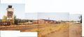
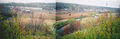
Composite panorama of the Kentville Railyard with the Kentville Track Scale in the centre & the foundation of the Kentville Machine Shop in the foreground, 1990.
South side of the Kentville Railyard looking west with the Kentville Track Scale with the Canada Foods Plant, October 1990.
Kentville Railyard looking east from the West Main Street crossing with the Canada Foods Plant, the Kentville Roundhouse, and the Kentville Car Shop, 1992.
The Kentville Railyard and the Kentville Roundhouse, October 29, 2005.
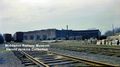
Kentville Railyard looking south, l to r: the British Canadian Fruit Association Kentville warehouse, W.J. Burrell's Machine Shop and the Kentville Roundhouse, May 10, 2006.
The Kentville Railyard and the Kentville Roundhouse after removal of all tracks, June 25, 2007.


