Dominion Atlantic Railway Digital Preservation Initiative - Wiki
Use of this site is subject to our Terms & Conditions.
Difference between revisions of "Ellershouse"
From DARwiki
Dan conlin (talk | contribs) (→Gallery: image) |
Dan Conlin (talk | contribs) m (→Gallery) |
||
| Line 19: | Line 19: | ||
==Gallery== | ==Gallery== | ||
<Gallery perrow=5> | <Gallery perrow=5> | ||
| + | File:A F Church Hants.jpg|Detail from A. F. Church Map, "Hants County", showing the route of the [[Windsor and Annapolis Railway]] through [[Stillwater]] and [[Ellershouse]], 1869. | ||
File:Newport-MtUniacke1909.jpg|DAR line from [[Newport]] to [[Mount Uniacke]], detail from 1909 geological map showing [[Hartville]], [[Ellershouse]], Dawson Siding, [[Stillwater]] and [[Claremont's]]. | File:Newport-MtUniacke1909.jpg|DAR line from [[Newport]] to [[Mount Uniacke]], detail from 1909 geological map showing [[Hartville]], [[Ellershouse]], Dawson Siding, [[Stillwater]] and [[Claremont's]]. | ||
File:HA-23.31 Ellershouse.jpg|1918 Track Chart of Ellershouse | File:HA-23.31 Ellershouse.jpg|1918 Track Chart of Ellershouse | ||
Revision as of 19:43, 5 January 2023
Ellershouse, Nova Scotia
Mile 23.24 from Windsor Junction on the Halifax Subdivision (Mile 39.05 from Halifax)
- Next Station East: Stillwater
- Next Station West: Hartville
Facilities & Features
- Ellershouse Station
- Passing Track
Commerce & Industry
Description & History
Operations & Orders
Gallery
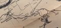
Detail from A. F. Church Map, "Hants County", showing the route of the Windsor and Annapolis Railway through Stillwater and Ellershouse, 1869.
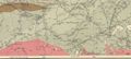
DAR line from Newport to Mount Uniacke, detail from 1909 geological map showing Hartville, Ellershouse, Dawson Siding, Stillwater and Claremont's.
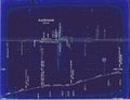
1918 Track Chart of Ellershouse
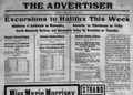
DAR specials to Ellershouse in The Kentville Advertiser, Sept. 24, 1918.
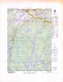
Topographic map from Falmouth to Ellershouse circa 1956.
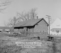
Ellershouse Station on December 4, 1960.


