Dominion Atlantic Railway Digital Preservation Initiative - Wiki
Use of this site is subject to our Terms & Conditions.
Difference between revisions of "Berwick"
Dan conlin (talk | contribs) (image) |
Dan conlin (talk | contribs) (history) |
||
| Line 12: | Line 12: | ||
==Description & History== | ==Description & History== | ||
| + | Located on a fertile height of land between the headwaters of the Cornwallis and Annapolis Rivers, Berwick was settled about 1810 when Benjamin Congdon built a farm on store at a crossroads near a bridge over the upper Cornwallis River. The community was known progressively as the "Congdon Settlement", "Curry's Corner", and "Davison's Corner" after various prominent families. Residents voted in 1851 to chose the name Berwick after the English town of Berwick-upon-Tweed.<ref>[https://novascotia.ca/archives/places/page.asp?ID=57 C. Bruce Fergusson, "Berwick", ''Place-Names and Places of Nova Scotia'' Nova Scotia Archives (1967), p. 57-58]</ref> | ||
| + | |||
| + | Berwick became a station on the [[Windsor & Annapolis Railway]] in 1869. The railway radically transformed the town, moving the centre of business a mile south away from the original Main Street by the Cornwallis River as businesses clustered along Commercial Street which led to the [[Berwick Station]]. The railway created a large export market for apples led by large scale farmers such as S. B. Chute and a number of apple co-operatives such as Berwick Fruit, all of whom built warehouses around the station. The railway also attracted spin-off industries such as the [[Berwick Evaporator]], the fruit processor M.W. Graves and the Berwcik Bakery.<ref>Ron Illsley, ''Berwick'' (2001)</ref> Berwick had rail service until Canadian Pacific abandoned the Dominion Atlantic tracks in March 1990. Today the DAR tracks are a popular multi-use recreational trail. | ||
==Operations & Orders== | ==Operations & Orders== | ||
| Line 18: | Line 21: | ||
==Gallery== | ==Gallery== | ||
<Gallery perrow=5> | <Gallery perrow=5> | ||
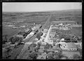
| − | Image:Berwick Railyard.JPG|[[Berwick]] railyard | + | Image:Berwick Railyard.JPG|[[Berwick]] railyard looking west with warehouse and [[Berwick Station|station]], May 1931. |
File:201216035.jpg | Sharper image of the Berwick Yard, July 1931. | File:201216035.jpg | Sharper image of the Berwick Yard, July 1931. | ||
| − | File:Berwick1931.jpg|Berwick looking | + | File:Berwick1931.jpg|Berwick looking north along Commercial Street, 1931. |
Image:1938 Berwick insurance map.JPG|Berwick Fire Insurance Map, 1938. | Image:1938 Berwick insurance map.JPG|Berwick Fire Insurance Map, 1938. | ||
File:Graves1940.jpg|H. W. Graves Plant, [[Berwick]]. c. 1940. | File:Graves1940.jpg|H. W. Graves Plant, [[Berwick]]. c. 1940. | ||
| Line 38: | Line 41: | ||
*[[1969-MemoOfGenInfo|1969 Memorandum of General Information]] | *[[1969-MemoOfGenInfo|1969 Memorandum of General Information]] | ||
<references /> | <references /> | ||
| − | + | <!-- If this article is commonly linked to, include a string that describes and can be copied and used to refer to this article such as for example: | |
| − | <!-- | ||
| − | If this article is commonly linked to, include a string that describes and can be copied and used to refer to this article such as for example: | ||
Please use this tag when referring to this article: Scotian Railroad Society, ''[[Zzzz Location Template|DAR Wiki Location Template]]'' | Please use this tag when referring to this article: Scotian Railroad Society, ''[[Zzzz Location Template|DAR Wiki Location Template]]'' | ||
--> | --> | ||
==External Links== | ==External Links== | ||
| − | + | *[http://www.berwicknovascotia.com Town of Berwick] | |
| + | *[http://www.acmuseum.ednet.ns.ca Apple Capital Museum] | ||
[[Category:Locations]] | [[Category:Locations]] | ||
[[Category:Subdivision Kentville|205]] | [[Category:Subdivision Kentville|205]] | ||
Revision as of 19:27, 27 April 2016
Berwick, Nova Scotia
Subdivision Kentville, Mile 12.3
- Next Station East: Waterville
- Next Station West: Aylesford
Facilities & Features
Commerce & Industry
Description & History
Located on a fertile height of land between the headwaters of the Cornwallis and Annapolis Rivers, Berwick was settled about 1810 when Benjamin Congdon built a farm on store at a crossroads near a bridge over the upper Cornwallis River. The community was known progressively as the "Congdon Settlement", "Curry's Corner", and "Davison's Corner" after various prominent families. Residents voted in 1851 to chose the name Berwick after the English town of Berwick-upon-Tweed.[1]
Berwick became a station on the Windsor & Annapolis Railway in 1869. The railway radically transformed the town, moving the centre of business a mile south away from the original Main Street by the Cornwallis River as businesses clustered along Commercial Street which led to the Berwick Station. The railway created a large export market for apples led by large scale farmers such as S. B. Chute and a number of apple co-operatives such as Berwick Fruit, all of whom built warehouses around the station. The railway also attracted spin-off industries such as the Berwick Evaporator, the fruit processor M.W. Graves and the Berwcik Bakery.[2] Berwick had rail service until Canadian Pacific abandoned the Dominion Atlantic tracks in March 1990. Today the DAR tracks are a popular multi-use recreational trail.
Operations & Orders
Gallery
Sharper image of the Berwick Yard, July 1931.
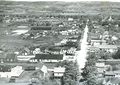
Berwick looking north along Commercial Street, 1931.
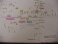
Berwick Fire Insurance Map, 1938.
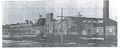
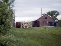
H. W. Graves Plant, Berwick. c. 1940.
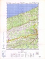
Topographic map from Berwick to Kentville circa 1956.
Berwick 1975.
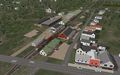
A digital model screen shot of Berwick circa 1975 on the Microsoft Train Simulator DAR Route authored by Paul Charland

D.A.R. trackage in Berwick, 1977.
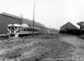
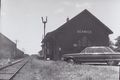
Dayliner at Berwick in August of 1977.
Eastbound dayliner arriving 1979.

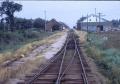
D.A.R. trackage in Berwick, 1987.
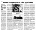
Article about the Berwick Evaporator, 2006


References & Footnotes
- Alexander MacNab, Windsor and Annapolis Railway, Report of Alexander MacNab Nov 1, 1873
- 1969 Memorandum of General Information
- ↑ C. Bruce Fergusson, "Berwick", Place-Names and Places of Nova Scotia Nova Scotia Archives (1967), p. 57-58
- ↑ Ron Illsley, Berwick (2001)