Dominion Atlantic Railway Digital Preservation Initiative - Wiki
Use of this site is subject to our Terms & Conditions.
Difference between revisions of "Gaspereaux River Bridge"
Dan conlin (talk | contribs) m |
|||
| Line 9: | Line 9: | ||
File:Wolfville_21_H1_West.jpg|Topographic map from Kentville to Hortons Landing circa 1956. | File:Wolfville_21_H1_West.jpg|Topographic map from Kentville to Hortons Landing circa 1956. | ||
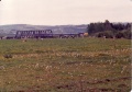
| − | File:Gaspereaux River Bridge 1958.jpg|[[Gaspereaux River Bridge]] looking eastward on July 31, 1958. | + | File:Gaspereaux River Bridge 1958.jpg|[[Gaspereaux River Bridge]] from the [[Horton Landing]] side looking eastward on July 31, 1958. |
Image:2010-03-20 Gaspereaux River Bridge a.jpg|Gaspereaux Bridge looking east, built in 1911 on March 20, 2010. | Image:2010-03-20 Gaspereaux River Bridge a.jpg|Gaspereaux Bridge looking east, built in 1911 on March 20, 2010. | ||
Revision as of 16:25, 29 November 2013
Gaspereaux River Bridge
Mile 44.5 on the Halifax Subdivision between Avonport and Horton Landing. The last of several DAR bridges over the Gaspereaux was built for the DAR in 1911 by the W.R. McNeil Company of New Glasgow, NS.(1) The bridge is 89 feet long and consists of 2 high deck plate girder spans, two steel truss spans and standard piles.(2)
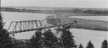
The Gaspereaux River Bridge looking east over the Gaspereaux River at Hortonville with Avonport in the distance.
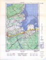
Topographic map from Kentville to Hortons Landing circa 1956.
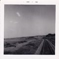
Gaspereaux River Bridge from the Horton Landing side looking eastward on July 31, 1958.
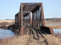
Gaspereaux Bridge looking east, built in 1911 on March 20, 2010.
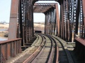
Gaspereaux Bridge looking east, built in 1911 on March 20, 2010.
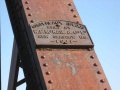
Gaspereaux Bridge builder's plate on March 20, 2010.
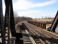
Gaspereaux Bridge looking west, built in 1911 on March 20, 2010.
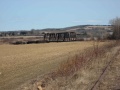
Gaspereaux Bridge looking south-east from a distance, built in 1911 on March 20, 2010.
VIA Apple Blossom Special, Westbound at Gaspereaux River Bridge.


References
(1) Cast iron builders plaque on bridge Nov. 11, 2009
(2) DAR Memorandum of General Information, page 5