Dominion Atlantic Railway Digital Preservation Initiative - Wiki
Use of this site is subject to our Terms & Conditions.
Difference between revisions of "Brooklyn"
From DARwiki
| Line 13: | Line 13: | ||
*[[Brooklyn Station]] | *[[Brooklyn Station]] | ||
| + | |||
| + | ==Description & History== | ||
==Gallery== | ==Gallery== | ||
| Line 18: | Line 20: | ||
File:Wolfville_21_H1_East.jpg|Topographic map from Avonport to Shaws Bog circa 1956. | File:Wolfville_21_H1_East.jpg|Topographic map from Avonport to Shaws Bog circa 1956. | ||
</Gallery> | </Gallery> | ||
| + | |||
| + | ==References & Footnotes== | ||
| + | *[[1969-MemoOfGenInfo|1969 Memorandum of General Information]] | ||
| + | <references /> | ||
| + | ==Reference Tag== | ||
==External Links== | ==External Links== | ||
Revision as of 06:35, 10 January 2013
Brooklyn, Hants County, Nova Scotia
Subdivision Truro, Mile 6.18
Next Station West: Scotch Village
Next Station East: Mantua
Facilities & Features
Description & History
Gallery
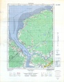
Topographic map from Avonport to Shaws Bog circa 1956.
