Dominion Atlantic Railway Digital Preservation Initiative - Wiki
Use of this site is subject to our Terms & Conditions.
Difference between revisions of "Sheffield Mills"
From DARwiki
Dan conlin (talk | contribs) (→Gallery: image) |
Dan conlin (talk | contribs) m (elevation) |
||
| Line 4: | Line 4: | ||
*[[:Category:Subdivision Kingsport|Subdivision Kingsport]], Mile 7.2 | *[[:Category:Subdivision Kingsport|Subdivision Kingsport]], Mile 7.2 | ||
| + | |||
| + | * Elevation: 92 feet<ref>[https://geoscan.nrcan.gc.ca/starweb/geoscan/servlet.starweb?path=geoscan/fulle.web&search1=R=108011 Map 13 A "PROVINCE OF NOVA SCOTIA, Kings and Hants CountIES, Kingsport Sheet No. 84"; Hugh Fletcher, L. N. Richard, Geological Survey of Canada, Dept. of Mines, Canada, Multicoloured Geological Map 1037, 1911]</ref> | ||
---- | ---- | ||
Revision as of 17:42, 6 May 2021
Sheffield Mills (Canard), Nova Scotia
- Subdivision Kingsport, Mile 7.2
- Elevation: 92 feet[1]
Previous Station: Ford Crossing (Gibson Woods)
Sheffield Mills Station with daytime agent operator
Siding, 15 cars, for five fruit warehouses
Next Station: Hillaton
Features
Gallery
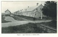
Sheffield Mills station and apple warehouses, circa 1930

Sheffield Mills Station, from the west, 1958.
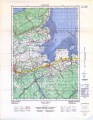
Topographic map from Kentville to Hortons Landing circa 1956.
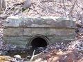
An 1880s Tile Pipe culvert at Sheffield Mills, April 20, 2008.


References and Footnotes
- Dominion Atlantic Railway Employee Time Table September 25, 1949, Library and Archives Canada, pmp -HE.2804 DC
External Links
[http://www.ve1bc.com/files/THE%20CORNWALLIS%20VALLEY%20RAILROAD.pdf "Cornwallis Valley Railway", a description of the railway landmarks and apple industry of Sheffield Mills by Spurgeon G. “Spud” Roscoe, p. 26-31]