Dominion Atlantic Railway Digital Preservation Initiative - Wiki
Use of this site is subject to our Terms & Conditions.
Difference between revisions of "Canning Wye and Spur"
From DARwiki
Dan conlin (talk | contribs) m |
Dan conlin (talk | contribs) (image) |
||
| Line 15: | Line 15: | ||
==Gallery== | ==Gallery== | ||
<Gallery> | <Gallery> | ||
| + | File:CanningSpur.jpg|Map of [[Canning Wye and Spur]] as designed April 28, 1911. | ||
</Gallery> | </Gallery> | ||
Revision as of 16:36, 23 March 2014
Canning Wye and Spur
- Subdivision Kingsport, Mile 9.8
Wye and 3,300 foot long spur in Canning leading to the Canning Wharf
- South leg: approx Mile 9.8
- North leg: approx Mile 10.1, a third of a mile from the Canning Station
- Active circa 1912-1920
- Included a 1000 foot trestle along the north side of the Habitant Rivert connecting to the Canning Wharf
- Wharf spur saw little use so trestle abandoned and salvaged by the Blenkhorne Axe Faxtory
- Wye continued to be used for the private railway car of Frederick William Borden, federal defence minister in WW I
Gallery
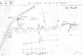
Map of Canning Wye and Spur as designed April 28, 1911.

References and Footnotes
Dan Conlin Field notes CVR Trip, April 20, 2008