Dominion Atlantic Railway Digital Preservation Initiative - Wiki
Use of this site is subject to our Terms & Conditions.
Difference between revisions of "Dimock's"
From DARwiki
Samuelmclark (talk | contribs) |
|||
| Line 23: | Line 23: | ||
<Gallery> | <Gallery> | ||
File:Windsor_21_A16_East.jpg|Topographic map from Falmouth to Ellershouse circa 1956. | File:Windsor_21_A16_East.jpg|Topographic map from Falmouth to Ellershouse circa 1956. | ||
| + | File:TruroSub-OldLoadingDocks.JPG|The old summer loading docks | ||
</Gallery> | </Gallery> | ||
| Line 28: | Line 29: | ||
For References, please list general references first. Leave the "cite" wiki markup in at the end and use the cite "<ref> and </ref> right in the text to footnote specific items. The Memorandum reference should be left unless the location or structures listed do not show up in the memorandum. | For References, please list general references first. Leave the "cite" wiki markup in at the end and use the cite "<ref> and </ref> right in the text to footnote specific items. The Memorandum reference should be left unless the location or structures listed do not show up in the memorandum. | ||
--> | --> | ||
| + | |||
==References & Footnotes== | ==References & Footnotes== | ||
*[[1969-MemoOfGenInfo|1969 Memorandum of General Information]] | *[[1969-MemoOfGenInfo|1969 Memorandum of General Information]] | ||
Revision as of 05:57, 18 November 2013
Dimock's, Nova Scotia
Subdivision Truro, Mile 2.25
Next Station East: Mantua
Next Station West: Windsor
Facilities & Features
- Wentworth Gypsum Quarry
- Summer Loading Docks (Prior to 1947)
See Gypsum Trains for more details.
Description & History
Operations & Orders
Gallery
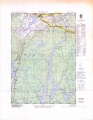
Topographic map from Falmouth to Ellershouse circa 1956.
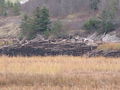
The old summer loading docks

