Dominion Atlantic Railway Digital Preservation Initiative - Wiki
Use of this site is subject to our Terms & Conditions.
Difference between revisions of "Ford Crossing"
From DARwiki
| Line 15: | Line 15: | ||
<Gallery> | <Gallery> | ||
File:Berwick 21 H2 East.jpg|Topographic map from Berwick to Kentville circa 1956. | File:Berwick 21 H2 East.jpg|Topographic map from Berwick to Kentville circa 1956. | ||
| + | File:Wolfville_21_H1_West.jpg|Topographic map from Kentville to Hortons Landing circa 1956. | ||
</Gallery> | </Gallery> | ||
Revision as of 14:02, 13 January 2012
Ford Crossing (Gibson Wood), Nova Scotia
- Subdivision Kingsport, Mile 6.1
Previous Station: Centreville
Flag Stop
Highest elevation of subdivision, 135 feet
Next Station: Sheffield Mills
Gallery
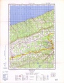
Topographic map from Berwick to Kentville circa 1956.
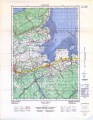
Topographic map from Kentville to Hortons Landing circa 1956.


References and Footnotes
- Dominion Atlantic Railway Employee Time Table September 25, 1949, Library and Archives Canada, pmp -HE.2804 DC