Dominion Atlantic Railway Digital Preservation Initiative - Wiki
Use of this site is subject to our Terms & Conditions.
Difference between revisions of "Habitant River Bridge"
From DARwiki
Dan conlin (talk | contribs) (images) |
|||
| Line 9: | Line 9: | ||
<Gallery> | <Gallery> | ||
File:Wolfville_21_H1_West.jpg|Topographic map from Kentville to Hortons Landing circa 1956. | File:Wolfville_21_H1_West.jpg|Topographic map from Kentville to Hortons Landing circa 1956. | ||
| + | File:Habitantsouth.JPG|Southern embankment & pilings of the [[Habitant River Bridge]] at [[Canning]], April 20, 2008. | ||
| + | File:Habitantsouthdetail.JPG|Southern embankment & pilings of the [[Habitant River Bridge]] at [[Canning]], April 20, 2008. | ||
| + | File:Habitantwest.JPG|Southern embankment & pilings of the [[Habitant River Bridge]] at [[Canning]], April 20, 2008. | ||
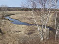
| + | File:Habitantnorth.JPG|North embankment of the [[Habitant River Bridge]] at [[Canning]], April 20, 2008. | ||
</Gallery> | </Gallery> | ||
Revision as of 14:25, 8 November 2013
Habitant River Bridge
- Subdivision Kingsport, Mile 9.2
Pile bridge over Habitant river, c. Mile 9.2
Gallery
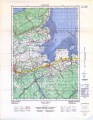
Topographic map from Kentville to Hortons Landing circa 1956.
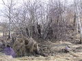
Southern embankment & pilings of the Habitant River Bridge at Canning, April 20, 2008.
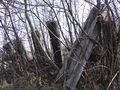
Southern embankment & pilings of the Habitant River Bridge at Canning, April 20, 2008.
Southern embankment & pilings of the Habitant River Bridge at Canning, April 20, 2008.
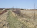
North embankment of the Habitant River Bridge at Canning, April 20, 2008.


