Dominion Atlantic Railway Digital Preservation Initiative - Wiki
Use of this site is subject to our Terms & Conditions.
Difference between revisions of "Hillaton"
Dan conlin (talk | contribs) (elevation) |
Dan Conlin (talk | contribs) m (→Gallery) |
||
| (7 intermediate revisions by 2 users not shown) | |||
| Line 4: | Line 4: | ||
[[:Category:Subdivision Kingsport|Subdivision Kingsport]], Mile 9.2 | [[:Category:Subdivision Kingsport|Subdivision Kingsport]], Mile 9.2 | ||
| + | |||
Elevation: 30 feet<ref>[https://geoscan.nrcan.gc.ca/starweb/geoscan/servlet.starweb?path=geoscan/fulle.web&search1=R=108011 Map 13 A "PROVINCE OF NOVA SCOTIA, Kings and Hants CountIES, Kingsport Sheet No. 84"; Hugh Fletcher, L. N. Richard, Geological Survey of Canada, Dept. of Mines, Canada, Multicoloured Geological Map 1037, 1911]</ref> | Elevation: 30 feet<ref>[https://geoscan.nrcan.gc.ca/starweb/geoscan/servlet.starweb?path=geoscan/fulle.web&search1=R=108011 Map 13 A "PROVINCE OF NOVA SCOTIA, Kings and Hants CountIES, Kingsport Sheet No. 84"; Hugh Fletcher, L. N. Richard, Geological Survey of Canada, Dept. of Mines, Canada, Multicoloured Geological Map 1037, 1911]</ref> | ||
| Line 14: | Line 15: | ||
Flag Stop, Mile 9.2 | Flag Stop, Mile 9.2 | ||
| − | 16 car siding with | + | 16 car siding with five [[:Category:Apple Warehouses|fruit warehouses]], east to west: British Canadian Fruit Association; Ridley Holdings, C.C.H. Eaton; R.A. Jodrey; and Canard Fruit Company Ltd.<ref>Dominion Atlantic Railway, ''[[1927-DAR CHART of Apple and Produce Warehouses|DAR Chart of Apple and Produce Warehouses, February 23, 1927]]''</ref><br> |
| − | + | [[Habitant River Bridge]], Mile 9.6 | |
==Gallery== | ==Gallery== | ||
<Gallery> | <Gallery> | ||
File:Wolfville_21_H1_West.jpg|Topographic map from Kentville to Hortons Landing circa 1956. | File:Wolfville_21_H1_West.jpg|Topographic map from Kentville to Hortons Landing circa 1956. | ||
| + | File:Kalkman076.jpg|[[:Category:Apple Warehouses|Apple Warehouses]] at [[Hillaton]] with [[DAR286510|CPR Refrigerator Car No. 286510]] on right, 1920s. | ||
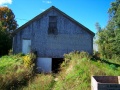
File:100 1312.jpg|[[Hillaton]] warehouse from southeast, October 2007 | File:100 1312.jpg|[[Hillaton]] warehouse from southeast, October 2007 | ||
File:100 1314.jpg|[[Hillaton]] warehouse from northeast, October 2007 | File:100 1314.jpg|[[Hillaton]] warehouse from northeast, October 2007 | ||
Latest revision as of 19:55, 22 February 2024
Hillaton, Nova Scotia
Subdivision Kingsport, Mile 9.2
Elevation: 30 feet[1]
- Next Station East: Canning
- Next Station West: Sheffield Mills
Spur for cold storage plant, Mile 8.9
Flag Stop, Mile 9.2
16 car siding with five fruit warehouses, east to west: British Canadian Fruit Association; Ridley Holdings, C.C.H. Eaton; R.A. Jodrey; and Canard Fruit Company Ltd.[2]
Habitant River Bridge, Mile 9.6
Gallery
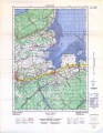
Topographic map from Kentville to Hortons Landing circa 1956.
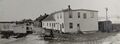
Apple Warehouses at Hillaton with CPR Refrigerator Car No. 286510 on right, 1920s.
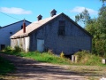
Hillaton warehouse from southeast, October 2007
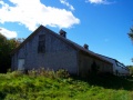
Hillaton warehouse from northeast, October 2007
Hillaton warehouse, east wall, October 2007

Ventilator detail Hillaton warehouse from southeast, October 2007
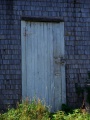
Freight door detail Hillaton warehouse, October 2007

Freight door & window detail Hillaton warehouse, October 2007
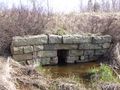
A Stone Box (S.B.) culvert at Hillaton, April 20, 2008


References and Footnotes
- Dominion Atlantic Railway Employee Time Table September 25, 1949, Library and Archives Canada, pmp -HE.2804 DC
External Links
- ↑ Map 13 A "PROVINCE OF NOVA SCOTIA, Kings and Hants CountIES, Kingsport Sheet No. 84"; Hugh Fletcher, L. N. Richard, Geological Survey of Canada, Dept. of Mines, Canada, Multicoloured Geological Map 1037, 1911
- ↑ Dominion Atlantic Railway, DAR Chart of Apple and Produce Warehouses, February 23, 1927