Dominion Atlantic Railway Digital Preservation Initiative - Wiki
Use of this site is subject to our Terms & Conditions.
Difference between revisions of "Auburn"
From DARwiki
Dan Conlin (talk | contribs) (alt name) |
|||
| (10 intermediate revisions by 2 users not shown) | |||
| Line 1: | Line 1: | ||
__NOTITLE__ __NOTOC__ | __NOTITLE__ __NOTOC__ | ||
=Auburn, Nova Scotia= | =Auburn, Nova Scotia= | ||
| + | (Also known as Morden Road) | ||
| + | |||
[[:Category:Subdivision Kentville|Subdivision Kentville]], Mile 19.1 | [[:Category:Subdivision Kentville|Subdivision Kentville]], Mile 19.1 | ||
| + | |||
| + | Elevation: 94.9 feet<ref>[[:Category:Louis Comeau|Louis Comeau]], [[Station List by Name COMEAU|''Dominion Atlantic Station List by Name'']], page 1</ref> | ||
| + | |||
*Next Station East: [[Aylesford]] | *Next Station East: [[Aylesford]] | ||
*Next Station West: [[Kingston]] | *Next Station West: [[Kingston]] | ||
| Line 9: | Line 14: | ||
==Commerce & Industry== | ==Commerce & Industry== | ||
| + | Two Apple Warehouses:<ref>Dominion Atlantic Railway, ''[[1927-DAR CHART of Apple and Produce Warehouses|DAR Chart of Apple and Produce Warehouses, February 23, 1927]]''</ref><br> | ||
| + | *Aylesford Fruit and Produce Shipping Company warehouse, (1927) 20,000 barrel capy. | ||
| + | *[[Herbert Oyler]] apple warehouse, (1927) 10,000 barrel capy. | ||
==Description & History== | ==Description & History== | ||
| + | Settled after the American Revolution, Auburn was named after a village in Westmeath, England. It became a farming community along the DAR, marked by its major landmark, the 1790s St. Mary's Anglican church, located just across the street from the train station.<ref>[https://archives.novascotia.ca/places/page/?ID=23 C. Bruce Fergusson, "Auburn", ''Place-Names and Places of Nova Scotia'' Nova Scotia Archives (1967), page 23.]</ref> | ||
==Operations & Orders== | ==Operations & Orders== | ||
| Line 17: | Line 26: | ||
==Gallery== | ==Gallery== | ||
<Gallery perrow=5> | <Gallery perrow=5> | ||
| + | File:KE-19.10 Auburn.jpg|Track chart of [[Auburn]], showing the [[Auburn Station]] and platform and [[:Category:Apple Warehouses|apple warehouses]], 1918. | ||
File:Berwick_21_H2_West.jpg|Topographic map from Auburn to Aylesford circa 1956. | File:Berwick_21_H2_West.jpg|Topographic map from Auburn to Aylesford circa 1956. | ||
| + | File:DAR-Auburn Station Sign Only-Harold Jenkins Photo-1July1961.JPG|[[Auburn]] station sign, July 1, 1961. | ||
</Gallery> | </Gallery> | ||
| Line 24: | Line 35: | ||
*[[1969-MemoOfGenInfo|1969 Memorandum of General Information]] | *[[1969-MemoOfGenInfo|1969 Memorandum of General Information]] | ||
<references /> | <references /> | ||
| − | |||
| − | |||
| − | |||
| − | |||
| − | |||
==External Links== | ==External Links== | ||
| − | |||
[[Category:Locations]] | [[Category:Locations]] | ||
[[Category:Subdivision Kentville|207]] | [[Category:Subdivision Kentville|207]] | ||
Latest revision as of 11:23, 7 February 2025
Auburn, Nova Scotia
(Also known as Morden Road)
Subdivision Kentville, Mile 19.1
Elevation: 94.9 feet[1]
Facilities & Features
Commerce & Industry
Two Apple Warehouses:[2]
- Aylesford Fruit and Produce Shipping Company warehouse, (1927) 20,000 barrel capy.
- Herbert Oyler apple warehouse, (1927) 10,000 barrel capy.
Description & History
Settled after the American Revolution, Auburn was named after a village in Westmeath, England. It became a farming community along the DAR, marked by its major landmark, the 1790s St. Mary's Anglican church, located just across the street from the train station.[3]
Operations & Orders
Gallery
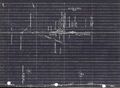
Track chart of Auburn, showing the Auburn Station and platform and apple warehouses, 1918.
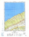
Topographic map from Auburn to Aylesford circa 1956.
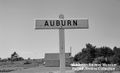
Auburn station sign, July 1, 1961.


References & Footnotes
- Alexander MacNab, Windsor and Annapolis Railway, Report of Alexander MacNab Nov 1, 1873
- 1969 Memorandum of General Information