Dominion Atlantic Railway Digital Preservation Initiative - Wiki
Use of this site is subject to our Terms & Conditions.
Difference between revisions of "Acaciaville"
From DARwiki
m |
Dan Conlin (talk | contribs) (map) |
||
| (7 intermediate revisions by 3 users not shown) | |||
| Line 1: | Line 1: | ||
=Acaciaville, Nova Scotia= | =Acaciaville, Nova Scotia= | ||
| − | Subdivision Yarmouth, Mile 24.20 | + | Subdivision Yarmouth, Mile 24.20<br> |
| + | Next Station East: [[Digby]]<br> | ||
| + | Next Station West: [[Bloomfield]] | ||
| + | |||
| + | Active as a station from approximately 1921 to 1979. Somewhere between 1915 and 1921 the station name for this area changed from Jordantown to Acaciaville. | ||
<br> | <br> | ||
| − | |||
<Gallery> | <Gallery> | ||
| + | File:YA-24.20_Acaciaville.jpg|Track chart for Acaciaville. | ||
| + | File:Acaciaville01.jpg|Happy folks at Acaciaville Station. Approximately 1927. | ||
| + | File:Acaciaville02.jpg|People on the Acaciaville Station platform. Approximately 1927. | ||
| + | File:Digby 21 A12 West.jpg|Topographical map of [[Digby]], [[Acaciaville]], [[Bloomfield]] and [[North Range]], 1952. | ||
</Gallery> | </Gallery> | ||
[[Category:Locations]] | [[Category:Locations]] | ||
[[Category:Subdivision Yarmouth|Y242]] | [[Category:Subdivision Yarmouth|Y242]] | ||
Latest revision as of 10:28, 10 January 2025
Acaciaville, Nova Scotia
Subdivision Yarmouth, Mile 24.20
Next Station East: Digby
Next Station West: Bloomfield
Active as a station from approximately 1921 to 1979. Somewhere between 1915 and 1921 the station name for this area changed from Jordantown to Acaciaville.
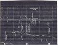
Track chart for Acaciaville.

Happy folks at Acaciaville Station. Approximately 1927.

People on the Acaciaville Station platform. Approximately 1927.
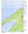
Topographical map of Digby, Acaciaville, Bloomfield and North Range, 1952.


