Dominion Atlantic Railway Digital Preservation Initiative - Wiki
Use of this site is subject to our Terms & Conditions.
Difference between revisions of "Mount Uniacke"
Dan Conlin (talk | contribs) (→Description & History: level crossing wigwag first installed) |
|||
| (33 intermediate revisions by 5 users not shown) | |||
| Line 1: | Line 1: | ||
| − | + | __NOTITLE__ __NOTOC__ | |
| − | Mile 12. | + | =Mount Uniacke, Nova Scotia= |
| + | Mile 12.77 from [[Windsor Junction]] on the [[:Category:Subdivision Halifax|Halifax Subdivision]] (Mile 28.51 from [[Halifax]]) | ||
| + | |||
| + | Elevation: 523 feet above sea level<ref>Dominion Atlantic Railway, ''[[1969-MemoOfGenInfo|1969 Memorandum of General Information]]'', page 2</ref> | ||
*Next Station East: [[South Uniacke]] | *Next Station East: [[South Uniacke]] | ||
| − | *Next Station West: [[ | + | *Next Station West: [[Claremont's]] |
==Facilities & Features== | ==Facilities & Features== | ||
| Line 9: | Line 12: | ||
*[[Mount Uniacke Water Tower]] | *[[Mount Uniacke Water Tower]] | ||
*Passing Track 1738 feet in length | *Passing Track 1738 feet in length | ||
| + | *WYE (removed sometime between 1951 & 1961) | ||
| + | |||
| + | ==Commerce & Industry== | ||
| + | *Mount Uniacke Gold Mines ~1862 - ~1946 <ref>[http://novascotia.ca/natr/meb/data/mg/ofm/pdf/ofm_2009-001_s29_dp.pdf Historic Map of Gold Mining areas.]</ref><ref>[http://news.google.com/newspapers?nid=53&dat=18690814&id=8xgHAAAAIBAJ&sjid=YTUDAAAAIBAJ&pg=5238,3914773 The British Colonist - Aug 14, 1869.]</ref><ref>[https://archive.org/details/cihm_00786 Alpha Gold Mining Company Prospectus.]</ref> | ||
| + | |||
| + | ==Description & History== | ||
| + | Mount Uniacke was named in 1830 after the large country estate of Richard John Uniacke located nearby. Construction of the Nova Scotia Railway came to the area in 1857. The first train arrived on June 3, 1858.<ref>Sadie Siroy, ''Doorsteps and Crossroads: Stories from Mount Uniacke, Lakelands, Hillsvale and South Rawdon'' (1993), p.3</ref> A small depot was built that year to serve as the [[Mount Uniacke Station]]. Gold was discovered nearby in 1862, triggering a gold rush which led to stores and hotels clustering around the station. A new station was built in 1884 and served until 1963. The Highway No. 1 level crossing at Mount Uniacke received one of the DAR's first set of wigwag warning signals and bell in 1938<ref>''[[:Category:The Advertiser|The Advertiser]]'', Sept. 29, 1938</ref>The last train passed through on November 2, 2010 when the [[:Category:Windsor and Hantsport Railway|Windsor and Hantsport Railway]], who had taken over the DAR's tracks, ceased operations.<ref>[https://www.youtube.com/watch?v=CPfnrduPyVc David Other, "WHRC's B23-7s including the last train to Windsor Junction", ''Youtube.com'']</ref> | ||
==Gallery== | ==Gallery== | ||
| − | <Gallery> | + | <Gallery perrow=5> |
| + | File:Mt Uniacke 1919.jpg|Passenger train stopped at [[Mount Uniacke Water Tower]] on November 8, 1919. | ||
| + | File:HA-12.77 Mount Uniacke Track Chart.JPG|Track schematic for [[Mount Uniacke]] showing the [[Mount Uniacke Station]] and a wye, undated. | ||
| + | File:Kalkman090.jpg|[[DAR0037|Dominion Atlantic locomotive No. 37]] at [[Mount Uniacke]], with roof of the [[Mount Uniacke Station]] in the background, May 2, 1927. | ||
File:Uniacke_11_D13.jpg|Topographic map from Stillwater to Windsor Junction circa 1956. | File:Uniacke_11_D13.jpg|Topographic map from Stillwater to Windsor Junction circa 1956. | ||
| − | + | File:CSTM-STR00625a 001 aa cs.jpg|Dayliner [[DAR9059|No. 9059]] at [[Mount Uniacke]], August 9, 1957. | |
Image:Mount Uniacke 1958.jpg|Wayfreight from [[Windsor Junction]] to [[Kentville]] passes [[Mount Uniacke Water Tower]] on July 31, 1958. | Image:Mount Uniacke 1958.jpg|Wayfreight from [[Windsor Junction]] to [[Kentville]] passes [[Mount Uniacke Water Tower]] on July 31, 1958. | ||
| + | File:DAR - Water Tank Tower - Mount Uniacke-Harold Jenkins Photo-4December1960.JPG|[[Mount Uniacke Water Tower]] and westbound tracks, photographed by [[:Category:Harold Jenkins Photo|Harold Jenkins]], December 4, 1960. | ||
| + | File:DAR - Mount Uniacke Station - Harold Jenkins Photo-Time 1600 20June1960.jpg|[[Mount Uniacke Station]], photographed by [[:Category:Harold Jenkins Photo|Harold Jenkins]], June 20, 1960. | ||
| + | Image:Mt. Uniacke Station 1961.jpg|[[Mount Uniacke]] station in 1961. | ||
| + | File:VIA RDCs Mount Uniacke lake sept 83 01.jpg|RDCs in the westbound Dayliner at [[Mount Uniacke]], across Lake Martha from the Uniacke House Museum, September 1983. | ||
| + | File:UniackeEstate2020.jpg|[[Mount Uniacke]], with namesake Mount Uniacke estate of Richard John Uniacke, March 22, 2020. | ||
| + | File:UniackeBridge.jpg|The 15-foot DPG bridge at [[Mount Uniacke]] over the channel between Lake Martha and Third Lake at Mile 14.05, March 20, 2020. | ||
</Gallery> | </Gallery> | ||
| + | |||
| + | ==References & Footnotes== | ||
| + | *[[1969-MemoOfGenInfo|1969 Memorandum of General Information]] | ||
| + | *[https://novascotia.ca/archives/places/page.asp?ID=458 C. Bruce Fergusson, "Beaver Bank", ''Place-Names and Places of Nova Scotia'' Nova Scotia Archives (1967), p. 47.] | ||
| + | <references /> | ||
| + | |||
| + | ==External Links== | ||
[[Category:Locations]] | [[Category:Locations]] | ||
| − | [[Category:Subdivision Halifax| | + | [[Category:Subdivision Halifax|HA-12.77]] |
Latest revision as of 17:38, 18 July 2024
Mount Uniacke, Nova Scotia
Mile 12.77 from Windsor Junction on the Halifax Subdivision (Mile 28.51 from Halifax)
Elevation: 523 feet above sea level[1]
- Next Station East: South Uniacke
- Next Station West: Claremont's
Facilities & Features
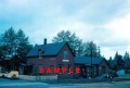
- Mount Uniacke Station
- Mount Uniacke Water Tower
- Passing Track 1738 feet in length
- WYE (removed sometime between 1951 & 1961)
Commerce & Industry
Description & History
Mount Uniacke was named in 1830 after the large country estate of Richard John Uniacke located nearby. Construction of the Nova Scotia Railway came to the area in 1857. The first train arrived on June 3, 1858.[5] A small depot was built that year to serve as the Mount Uniacke Station. Gold was discovered nearby in 1862, triggering a gold rush which led to stores and hotels clustering around the station. A new station was built in 1884 and served until 1963. The Highway No. 1 level crossing at Mount Uniacke received one of the DAR's first set of wigwag warning signals and bell in 1938[6]The last train passed through on November 2, 2010 when the Windsor and Hantsport Railway, who had taken over the DAR's tracks, ceased operations.[7]
Gallery
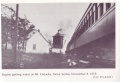
Passenger train stopped at Mount Uniacke Water Tower on November 8, 1919.
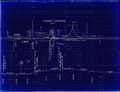
Track schematic for Mount Uniacke showing the Mount Uniacke Station and a wye, undated.
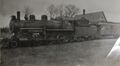
Dominion Atlantic locomotive No. 37 at Mount Uniacke, with roof of the Mount Uniacke Station in the background, May 2, 1927.
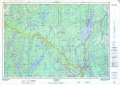
Topographic map from Stillwater to Windsor Junction circa 1956.
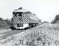
Dayliner No. 9059 at Mount Uniacke, August 9, 1957.
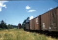
Wayfreight from Windsor Junction to Kentville passes Mount Uniacke Water Tower on July 31, 1958.
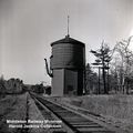
Mount Uniacke Water Tower and westbound tracks, photographed by Harold Jenkins, December 4, 1960.
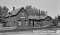
Mount Uniacke Station, photographed by Harold Jenkins, June 20, 1960.
Mount Uniacke station in 1961.
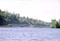
RDCs in the westbound Dayliner at Mount Uniacke, across Lake Martha from the Uniacke House Museum, September 1983.
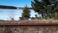
Mount Uniacke, with namesake Mount Uniacke estate of Richard John Uniacke, March 22, 2020.
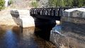
The 15-foot DPG bridge at Mount Uniacke over the channel between Lake Martha and Third Lake at Mile 14.05, March 20, 2020.


References & Footnotes
- 1969 Memorandum of General Information
- C. Bruce Fergusson, "Beaver Bank", Place-Names and Places of Nova Scotia Nova Scotia Archives (1967), p. 47.
- ↑ Dominion Atlantic Railway, 1969 Memorandum of General Information, page 2
- ↑ Historic Map of Gold Mining areas.
- ↑ The British Colonist - Aug 14, 1869.
- ↑ Alpha Gold Mining Company Prospectus.
- ↑ Sadie Siroy, Doorsteps and Crossroads: Stories from Mount Uniacke, Lakelands, Hillsvale and South Rawdon (1993), p.3
- ↑ The Advertiser, Sept. 29, 1938
- ↑ David Other, "WHRC's B23-7s including the last train to Windsor Junction", Youtube.com