Dominion Atlantic Railway Digital Preservation Initiative - Wiki
Use of this site is subject to our Terms & Conditions.
Difference between revisions of "South Maitland"
Dan conlin (talk | contribs) (history) |
Dan Conlin (talk | contribs) m (→Gallery) |
||
| (28 intermediate revisions by 3 users not shown) | |||
| Line 1: | Line 1: | ||
__NOTITLE__ | __NOTITLE__ | ||
__NOTOC__ | __NOTOC__ | ||
| − | |||
=South Maitland, Nova Scotia= | =South Maitland, Nova Scotia= | ||
[[:Category:Subdivision Truro|Truro Subdivision, the Midland Line]], Mile 40.27 | [[:Category:Subdivision Truro|Truro Subdivision, the Midland Line]], Mile 40.27 | ||
| − | Next Station East: [[Green Oaks]] | + | * Next Station East: [[Green Oaks]] |
| − | + | * Next Station West: [[Burtons]] | |
| − | Next Station West: [[Burtons]] | ||
==Facilities & Features== | ==Facilities & Features== | ||
| Line 15: | Line 13: | ||
*[[South Maitland Water Tower]] | *[[South Maitland Water Tower]] | ||
*[[South Maitland Bridge]] | *[[South Maitland Bridge]] | ||
| + | *1316 foot passing siding | ||
| + | *[[Hayes Pit|Hayes Pit Quarry]], Mile 37.3 | ||
==Description & History== | ==Description & History== | ||
| − | This village on the Shubenacadie River was once a major shipbuilding and timber community as well as home to gypsum quarries. It became an important stop on the [[:Category:Subdivision Truro|Midland Line]] with [[South Maitland Station|substancial station]], [[South Maitland Water Tower|water tower]] and most notably, the [[South Maitland Bridge|large swing bridge over the Shubenacadie River]]. | + | This village on the Shubenacadie River was once a major shipbuilding and timber community as well as home to gypsum quarries. It became an important stop on the [[:Category:Subdivision Truro|Midland Line]] with [[South Maitland Station|substancial station]], [[South Maitland Water Tower|water tower]] and most notably, the [[South Maitland Bridge|large swing bridge over the Shubenacadie River]]. In World War II, south Maitland served as the supply point for the training air field at Maitland. Rail service ended while the line was closed in 1983. In 2006 the Fundy Tidal Interpretation Centre opened at South Maitland beside the old DAR roadbed. The centre includes a retired Canadian National caboose No. 79770<ref>''Canadian Trackside Guide'' (2008), p.3-110</ref> painted with retro DAR lettering and a hiking trail that leads to a look-off built on the piers of the swing span of the DAR's old [[South Maitland Bridge]]. |
==Operations & Orders== | ==Operations & Orders== | ||
| Line 23: | Line 23: | ||
==Gallery== | ==Gallery== | ||
<Gallery> | <Gallery> | ||
| + | Image:Midland bridge 00.jpg|MRC Locomotive [[DAR0031|No. 1]] on the [[South Maitland Bridge]] construction site, circa 1900. | ||
| + | Image:Midland bridge 01.jpg|The [[South Maitland Bridge]] under construction, circa 1900. | ||
| + | Image:Midland bridge 02.jpg|A truss span arrives at the [[South Maitland Bridge]], circa 1900. | ||
| + | Image:Midland bridge 03.jpg|A truss span moves into place at the [[South Maitland Bridge]], circa 1900. | ||
| + | File:Kalkman101.jpg|Opening of [[:Category:Subdivision Truro|Midland Line]] probably at [[South Maitland]] with [[DAR000006|Coach No. 6]], 1900 or 1905. | ||
| + | File: Engine25Strathcona-Midland1907.png |[[DAR0027|Engine 25 "Strathcona"]] at the [[South Maitland Station]], heading to Truro with Picnic Special, June 21, 1907. | ||
| + | Image:DAR0029a.jpg|[[DAR0029|No. 29]] "Brooklyn" at [[South Maitland Station]], circa 1910. | ||
| + | File:DHP044202-DEV01514.jpg|[[South Maitland Bridge]], Nova Scotia Museum postcard, circa 1910. | ||
| + | File:H7.jpg|[[South Maitland Station]], February 1948. | ||
| + | File:H521.jpg|Loading a flat car at [[South Maitland]], February 1948. | ||
| + | File:H58.jpg|Loading flat cars at [[South Maitland]], February 1948. | ||
| + | Image:Train No. 22.jpg|[[Train No. 22]] near [[South Maitland]] on August 1, 1958 | ||
| + | Image:South Maitland Station 1958.jpg|[[South Maitland Station]] taken from rear of [[Train No. 22]] on August 1, 1958. | ||
| + | Image:Shubenacadie River Bridge 1958 a.jpg|[[South Maitland Bridge]] over the Schubenacadie River near [[South Maitland]] on August 1, 1958. | ||
| + | Image:Shubenacadie River Bridge 1958 b.jpg|[[South Maitland Bridge]] over the Schubenacadie River, near [[South Maitland]] from the rear of [[Train No. 22]] on August 1, 1958. | ||
| + | File:DAR - South Maitland Station Coach on Siding-Harold Jenkins Photo-June1959.JPG |[[South Maitland Station]] and siding with a DAR coach, June 1959. | ||
| + | File:DAR - Shubenacadie Bridge West Bank-2May1987.jpg|[[South Maitland Bridge]], west bank, May 2, 1987. | ||
| + | File:Shubiebridge1.JPG|The [[South Maitland Bridge]] showing the new observation deck with new highway bridge to right, September 5, 2013. | ||
</Gallery> | </Gallery> | ||
| Line 28: | Line 46: | ||
For References, please list general references first. Leave the "cite" wiki markup in at the end and use the cite "<ref> and </ref> right in the text to footnote specific items. The Memorandum reference should be left unless the location or structures listed do not show up in the memorandum. | For References, please list general references first. Leave the "cite" wiki markup in at the end and use the cite "<ref> and </ref> right in the text to footnote specific items. The Memorandum reference should be left unless the location or structures listed do not show up in the memorandum. | ||
--> | --> | ||
| + | |||
==References & Footnotes== | ==References & Footnotes== | ||
| − | *[[1969-MemoOfGenInfo|1969 Memorandum of General Information]] | + | *[[1969-MemoOfGenInfo|1969 Memorandum of General Information, page 22]] |
| − | <references /> | + | <references/> |
==External Links== | ==External Links== | ||
| + | * https://www.easthants.ca/visitors/attractions-events/fundy-tidal-interpretive-centre/|Fundy Tidal Interpretive Centre] at South Maitland | ||
| + | *[http://www.images.technomuses.ca/searchpf.php?id=15184&lang=en Engine 29 at South Maintland - Canada Science and Technology Museum, Image STR09885a] | ||
[[Category:Locations]] | [[Category:Locations]] | ||
[[Category:Subdivision Truro|402]] | [[Category:Subdivision Truro|402]] | ||
Latest revision as of 16:21, 13 May 2024
South Maitland, Nova Scotia
Truro Subdivision, the Midland Line, Mile 40.27
- Next Station East: Green Oaks
- Next Station West: Burtons
Facilities & Features
- South Maitland Station
- South Maitland Water Tower
- South Maitland Bridge
- 1316 foot passing siding
- Hayes Pit Quarry, Mile 37.3
Description & History
This village on the Shubenacadie River was once a major shipbuilding and timber community as well as home to gypsum quarries. It became an important stop on the Midland Line with substancial station, water tower and most notably, the large swing bridge over the Shubenacadie River. In World War II, south Maitland served as the supply point for the training air field at Maitland. Rail service ended while the line was closed in 1983. In 2006 the Fundy Tidal Interpretation Centre opened at South Maitland beside the old DAR roadbed. The centre includes a retired Canadian National caboose No. 79770[1] painted with retro DAR lettering and a hiking trail that leads to a look-off built on the piers of the swing span of the DAR's old South Maitland Bridge.
Operations & Orders
Gallery
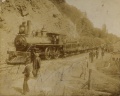
MRC Locomotive No. 1 on the South Maitland Bridge construction site, circa 1900.
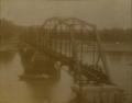
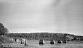
The South Maitland Bridge under construction, circa 1900.
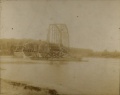
A truss span arrives at the South Maitland Bridge, circa 1900.
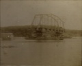
A truss span moves into place at the South Maitland Bridge, circa 1900.

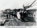
Opening of Midland Line probably at South Maitland with Coach No. 6, 1900 or 1905.
Engine 25 "Strathcona" at the South Maitland Station, heading to Truro with Picnic Special, June 21, 1907.
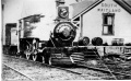
No. 29 "Brooklyn" at South Maitland Station, circa 1910.

South Maitland Bridge, Nova Scotia Museum postcard, circa 1910.
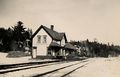
South Maitland Station, February 1948.
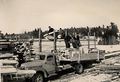
Loading a flat car at South Maitland, February 1948.
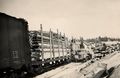
Loading flat cars at South Maitland, February 1948.
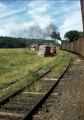
Train No. 22 near South Maitland on August 1, 1958
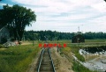
South Maitland Station taken from rear of Train No. 22 on August 1, 1958.
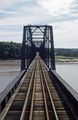
South Maitland Bridge over the Schubenacadie River near South Maitland on August 1, 1958.
South Maitland Bridge over the Schubenacadie River, near South Maitland from the rear of Train No. 22 on August 1, 1958.
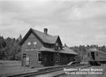
South Maitland Station and siding with a DAR coach, June 1959.
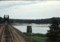
South Maitland Bridge, west bank, May 2, 1987.
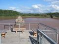
The South Maitland Bridge showing the new observation deck with new highway bridge to right, September 5, 2013.


References & Footnotes
- ↑ Canadian Trackside Guide (2008), p.3-110
External Links
- https://www.easthants.ca/visitors/attractions-events/fundy-tidal-interpretive-centre/%7CFundy Tidal Interpretive Centre] at South Maitland
- Engine 29 at South Maintland - Canada Science and Technology Museum, Image STR09885a