Dominion Atlantic Railway Digital Preservation Initiative - Wiki
Use of this site is subject to our Terms & Conditions.
Difference between revisions of "South Uniacke"
From DARwiki
Dan Conlin (talk | contribs) (image) |
Dan Conlin (talk | contribs) (image) |
||
| Line 13: | Line 13: | ||
==Gallery== | ==Gallery== | ||
<Gallery perrow=5> | <Gallery perrow=5> | ||
| + | File:Kalkman71.jpg|The [[South Uniacke]] station, with Johnie Sweet, date unknown. | ||
File:HA-10.93 Hibbit.jpg|Track Schematic showing Hibbit's and bridge over Sackville River. | File:HA-10.93 Hibbit.jpg|Track Schematic showing Hibbit's and bridge over Sackville River. | ||
File:HA-10.19 South Uniacke Track Chart.JPG|Track schematic for [[South Uniacke]], siding removal dated 1955. | File:HA-10.19 South Uniacke Track Chart.JPG|Track schematic for [[South Uniacke]], siding removal dated 1955. | ||
Latest revision as of 18:33, 12 October 2023
South Uniacke, Nova Scotia
Mile 10.2 from Windsor Junction on the Halifax Subdivision (Mile 25.93 from Halifax)
- Next Station East: Groves
- Next Station West: Mount Uniacke
Facilities & Features
- Small station and platform
- Spur to Hibbit's at Mile 10.93 (in 1931 and 1951). Removed in 1955.
- Bridge over Sackville River, 104-feet-long at Mile 10.5
Gallery
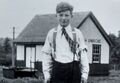
The South Uniacke station, with Johnie Sweet, date unknown.
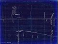
Track Schematic showing Hibbit's and bridge over Sackville River.
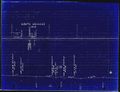
Track schematic for South Uniacke, siding removal dated 1955.
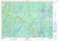
Topographic map from Stillwater to Windsor Junction circa 1956.

South Uniacke station sign, May 5, 1963.


References & Footnotes