Dominion Atlantic Railway Digital Preservation Initiative - Wiki
Use of this site is subject to our Terms & Conditions.
Difference between revisions of "Claremont's"
Dan conlin (talk | contribs) |
Dan Conlin (talk | contribs) |
||
| (11 intermediate revisions by 2 users not shown) | |||
| Line 12: | Line 12: | ||
==Facilities & Features== | ==Facilities & Features== | ||
| − | * Siding, circa 1900 | + | * Siding, for nearby Lakelands settlement, circa 1900 |
* Proposed Station, never built, 1910 | * Proposed Station, never built, 1910 | ||
| + | * Siding for ballast steam shovel, Mile 18 | ||
<!-- Please create sub-pages for the following faculties & features if they exist and add the appropriate category tags to the sub page so that the structures list in the appropriate structures index. This is especially important for stations. We do not list sidings as a sub page. Just put them in as a feature line: | <!-- Please create sub-pages for the following faculties & features if they exist and add the appropriate category tags to the sub page so that the structures list in the appropriate structures index. This is especially important for stations. We do not list sidings as a sub page. Just put them in as a feature line: | ||
| Line 30: | Line 31: | ||
--> | --> | ||
==Commerce & Industry== | ==Commerce & Industry== | ||
| − | Once contained a siding, likely used by the Clairmont Family in nearby | + | Once contained a siding, likely used by the Clairmont Family in nearby Lakelands. |
<!-- | <!-- | ||
* [[Apple Warehouse(s)]] | * [[Apple Warehouse(s)]] | ||
| Line 36: | Line 37: | ||
--> | --> | ||
<!-- Tell us all about this place --> | <!-- Tell us all about this place --> | ||
| + | |||
==Description & History== | ==Description & History== | ||
| − | + | Claremont's is located a few miles south of the village of Lakelands. It is believed to have been named after Colonel Clairmont, a prominent family head in Lakeside active in lumbering. In 1910 architect Charles McClare attempted to develop a landscaped suburban community at Lakelands in a real estate scheme called the "Lakelands Development Company". A critical feature was a suburban train station to connect the wealthy new residents to Halifax. McClare drew plans for a finely-constructed stone station for Claremont's which he promised "will be certainly the most interesting station on the entire line between Halifax and Yarmouth." The development failed to attract enough investors and collapsed. None of the fine homes or the station were ever built.<ref>Sadie Siroy, ''Doorsteps and Crossroads: Stories from Mount Uniacke, Lakelands, Hillsvale and South Rawdon'' (1993). p. 10-14, 45.</ref> Just west of Claremont's, a cutting through a bank of glacial till provided a small ballast pit known as Steam Shovel Siding. | |
==Gallery== | ==Gallery== | ||
| − | <Gallery perrow=5> <!-- This sets the number of gallery columns to 5 even though it says row.--> | + | <Gallery perrow=5> <!-- This sets the number of gallery columns to 5 even though it says row.-->\ |
| + | File:Newport-MtUniacke1909.jpg|DAR line from [[Newport]] to [[Mount Uniacke]], detail from 1909 geological map showing [[Hartville]], [[Ellershouse]], Dawson Siding, [[Stillwater]] and [[Claremont's]]. | ||
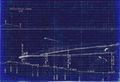
File:HA-16.47 Claremont's.jpg|1918 Track chart showing the Clairmont's area. | File:HA-16.47 Claremont's.jpg|1918 Track chart showing the Clairmont's area. | ||
| + | File:HA-18.00 Steam Shovel Siding.jpg|1918 track chart showing Steam Shovel Siding at Mile 18, just west of [[Claremont's]]. | ||
| + | File:LakelandsStation.jpg|The proposed station at [[Claremont's|Claremont's Siding]], planned but never built to serve nearby Lakelands, 1910. | ||
| + | File:ClaremontsSiding.jpg|[[Claremont's|Claremont's Siding]], looking west, showing DAR mainline with the overgrown siding curving off to the right, Mar. 22, 2020. | ||
| + | *[[:Category:Dan Conlin Photo|Dan Conlin photo]] | ||
| + | |||
| + | [[Category:Dan Conlin Photo]] | ||
</Gallery> | </Gallery> | ||
<!-- For References, please list general references first. Leave the "cite" wiki markup in at the end and use the cite "<ref> and </ref> right in the text to footnote specific items. The Memorandum reference should be left unless the location or structures listed do not show up in the memorandum. --> | <!-- For References, please list general references first. Leave the "cite" wiki markup in at the end and use the cite "<ref> and </ref> right in the text to footnote specific items. The Memorandum reference should be left unless the location or structures listed do not show up in the memorandum. --> | ||
| + | |||
==References & Footnotes== | ==References & Footnotes== | ||
*[[1969-MemoOfGenInfo|1969 Memorandum of General Information]] | *[[1969-MemoOfGenInfo|1969 Memorandum of General Information]] | ||
| Line 54: | Line 64: | ||
==External Links== | ==External Links== | ||
| + | [https://novascotia.ca/archives/places/page.asp?ID=339 C. Bruce Fergusson, "Lakelands", ''Place-Names and Places of Nova Scotia'' Nova Scotia Archives (1967), p. 339.] | ||
[[Category:Locations]] | [[Category:Locations]] | ||
[[Category:Subdivision Halifax|HA-16.47]] | [[Category:Subdivision Halifax|HA-16.47]] | ||
<!-- Enter the correct subdivision category for this location and for the |xxx number, use the track mileage and the first decimal place without the period. For number less than 10, use a leading 0 so that the there are always 3 digits to this number This keeps the locations in the proper order. --> | <!-- Enter the correct subdivision category for this location and for the |xxx number, use the track mileage and the first decimal place without the period. For number less than 10, use a leading 0 so that the there are always 3 digits to this number This keeps the locations in the proper order. --> | ||
Latest revision as of 20:01, 5 January 2023
Claremont's, Nova Scotia (Also known as "Clairmont's Siding")
Subdivision Halifax, Mile 16.47, Elevation 460'
Next Station West: Stillwater Lake
Next Station East: Mount Uniacke
Facilities & Features
- Siding, for nearby Lakelands settlement, circa 1900
- Proposed Station, never built, 1910
- Siding for ballast steam shovel, Mile 18
Commerce & Industry
Once contained a siding, likely used by the Clairmont Family in nearby Lakelands.
Description & History
Claremont's is located a few miles south of the village of Lakelands. It is believed to have been named after Colonel Clairmont, a prominent family head in Lakeside active in lumbering. In 1910 architect Charles McClare attempted to develop a landscaped suburban community at Lakelands in a real estate scheme called the "Lakelands Development Company". A critical feature was a suburban train station to connect the wealthy new residents to Halifax. McClare drew plans for a finely-constructed stone station for Claremont's which he promised "will be certainly the most interesting station on the entire line between Halifax and Yarmouth." The development failed to attract enough investors and collapsed. None of the fine homes or the station were ever built.[1] Just west of Claremont's, a cutting through a bank of glacial till provided a small ballast pit known as Steam Shovel Siding.
Gallery
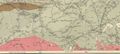
DAR line from Newport to Mount Uniacke, detail from 1909 geological map showing Hartville, Ellershouse, Dawson Siding, Stillwater and Claremont's.

1918 Track chart showing the Clairmont's area.
1918 track chart showing Steam Shovel Siding at Mile 18, just west of Claremont's.
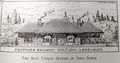
The proposed station at Claremont's Siding, planned but never built to serve nearby Lakelands, 1910.
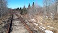
Claremont's Siding, looking west, showing DAR mainline with the overgrown siding curving off to the right, Mar. 22, 2020.


References & Footnotes
- ↑ Sadie Siroy, Doorsteps and Crossroads: Stories from Mount Uniacke, Lakelands, Hillsvale and South Rawdon (1993). p. 10-14, 45.