Dominion Atlantic Railway Digital Preservation Initiative - Wiki
Use of this site is subject to our Terms & Conditions.
Difference between revisions of "Plympton"
From DARwiki
Dan Conlin (talk | contribs) m |
Dan Conlin (talk | contribs) (image) |
||
| Line 3: | Line 3: | ||
==Facilities and Features== | ==Facilities and Features== | ||
| − | [[Plympton Station]] | + | * [[Plympton Station]] |
| + | * Spur line to Ballast Pit | ||
==Gallery== | ==Gallery== | ||
<Gallery> | <Gallery> | ||
| + | File:YA-33.74 Plympton.jpg|CPR track profile drawing showing [[Plympton]], including the spur line to the Plympton ballast pit, 1918. | ||
File:Weymouth 21 A5 West.jpg|Topographical map of the [[Weymouth]] area, including [[Sissiboo Falls]] and [[Plympton]] and the 1919-1928 branch line to the [[Sissiboo Pulp and Paper]] Company, 1950. | File:Weymouth 21 A5 West.jpg|Topographical map of the [[Weymouth]] area, including [[Sissiboo Falls]] and [[Plympton]] and the 1919-1928 branch line to the [[Sissiboo Pulp and Paper]] Company, 1950. | ||
</Gallery> | </Gallery> | ||
Revision as of 19:26, 12 November 2021
Plympton, Nova Scotia
Subdivision Yarmouth, Mile 33.7
Facilities and Features
- Plympton Station
- Spur line to Ballast Pit
Gallery
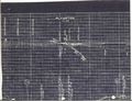
CPR track profile drawing showing Plympton, including the spur line to the Plympton ballast pit, 1918.
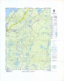
Topographical map of the Weymouth area, including Sissiboo Falls and Plympton and the 1919-1928 branch line to the Sissiboo Pulp and Paper Company, 1950.

