Dominion Atlantic Railway Digital Preservation Initiative - Wiki
Use of this site is subject to our Terms & Conditions.
Difference between revisions of "St. Croix River Bridge"
Dan Conlin (talk | contribs) (→St. Croix River Bridge: specs) |
Dan Conlin (talk | contribs) (elevation, map images, fixed footnotes) |
||
| Line 11: | Line 11: | ||
This bridge at [[Mantua]] crossed the deep tidal estuary of the St. Croix River and was the second largest on the Midland subdivision. It was active until the final days of the line carrying gypsum trains from the Miller Creek quarry at Mantua until the quarries and the line closed in 2011. | This bridge at [[Mantua]] crossed the deep tidal estuary of the St. Croix River and was the second largest on the Midland subdivision. It was active until the final days of the line carrying gypsum trains from the Miller Creek quarry at Mantua until the quarries and the line closed in 2011. | ||
| − | ==First Bridge 1899- | + | ==First Bridge 1899-XXXX== |
| − | A temporary timber bridge crossed the St. Croix during construction of the Midland Line, replaced by the first permanent bridge | + | A temporary timber bridge crossed the St. Croix during construction of the Midland Line, replaced by the first permanent bridge. |
| + | *Two 120 foot spans | ||
| + | *One 34-foot lift draw span<ref>[[The_Railway_and_Shipping_World_-_1899-05_-_Midland_Railway_Bridges_and_Route_Details]]</ref> | ||
==Second Bridge XXXX-Present Day== | ==Second Bridge XXXX-Present Day== | ||
| Line 19: | Line 21: | ||
Length: 459 feet | Length: 459 feet | ||
| − | Height to Rail Elevation: | + | Height to Rail Elevation: 35 feet |
| − | Height to Rail above | + | Height to Rail above river at high tide: 30 feet |
*Treated Pile Trestle | *Treated Pile Trestle | ||
*Two Through Truss spans | *Two Through Truss spans | ||
*Three 150-foot Deck Truss spans | *Three 150-foot Deck Truss spans | ||
| − | *One Deck Plate Girder span | + | *One Deck Plate Girder span<ref>Dominion Atlantic Railway, ''[[1969-MemoOfGenInfo|1969 Memorandum of General Information]]'', page 21.</ref> |
| − | <ref>Dominion Atlantic Railway, ''[[1969-MemoOfGenInfo|1969 Memorandum of General Information]]'', page 21.</ref> | ||
===Gallery=== | ===Gallery=== | ||
<gallery> | <gallery> | ||
| + | File:Quarries.jpg|[[:Category:Gypsum_Trains|Gypsum quarry]] spurs in the [[Windsor]]] area,showing the location and elevation of the St. Croix River bridge from geological map, 1909. | ||
File:TruroSub-StCroixBridge.JPG|[[St. Croix River Bridge]] just west of [[Mantua]], photo is from West side of the bridge looking east, 500 to 800 Meters from the bridge, Nov. 11, 2013. | File:TruroSub-StCroixBridge.JPG|[[St. Croix River Bridge]] just west of [[Mantua]], photo is from West side of the bridge looking east, 500 to 800 Meters from the bridge, Nov. 11, 2013. | ||
</gallery> | </gallery> | ||
| Line 41: | Line 43: | ||
==External Links== | ==External Links== | ||
| − | [https://www.youtube.com/watch?v=_DO2aOU6aa0 Spring Blossoms and Rusty Train Bridge on the St. Croix River] | + | [https://www.youtube.com/watch?v=_DO2aOU6aa0 Drone Video "Spring Blossoms and Rusty Train Bridge on the St. Croix River"] |
[[Category:Bridges]] | [[Category:Bridges]] | ||
[[Category:Subdivision Truro|37]] | [[Category:Subdivision Truro|37]] | ||
Revision as of 06:50, 31 August 2021
St. Croix River Bridge
Mileage: 3.71
Subdivision: Truro
Description
This bridge at Mantua crossed the deep tidal estuary of the St. Croix River and was the second largest on the Midland subdivision. It was active until the final days of the line carrying gypsum trains from the Miller Creek quarry at Mantua until the quarries and the line closed in 2011.
First Bridge 1899-XXXX
A temporary timber bridge crossed the St. Croix during construction of the Midland Line, replaced by the first permanent bridge.
- Two 120 foot spans
- One 34-foot lift draw span[1]
Second Bridge XXXX-Present Day
The final railway bridge over the St. Croix still stands today with two fixed truss spans and a mix of approach spans.
Length: 459 feet
Height to Rail Elevation: 35 feet
Height to Rail above river at high tide: 30 feet
- Treated Pile Trestle
- Two Through Truss spans
- Three 150-foot Deck Truss spans
- One Deck Plate Girder span[2]
Gallery

Gypsum quarry spurs in the Windsor] area,showing the location and elevation of the St. Croix River bridge from geological map, 1909.
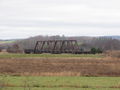
St. Croix River Bridge just west of Mantua, photo is from West side of the bridge looking east, 500 to 800 Meters from the bridge, Nov. 11, 2013.


References
- ↑ The_Railway_and_Shipping_World_-_1899-05_-_Midland_Railway_Bridges_and_Route_Details
- ↑ Dominion Atlantic Railway, 1969 Memorandum of General Information, page 21.
- https://dardpi.ca/wiki/index.php?title=The_Railway_and_Shipping_World_-_1898-07_-_Midland_Contractors
- https://dardpi.ca/wiki/index.php?title=The_Railway_and_Shipping_World_-_1899-01_-_Midland_Railway_Route_Decision
External Links
Drone Video "Spring Blossoms and Rusty Train Bridge on the St. Croix River"