Dominion Atlantic Railway Digital Preservation Initiative - Wiki
Use of this site is subject to our Terms & Conditions.
Difference between revisions of "Canning Wye and Spur"
From DARwiki
Dan conlin (talk | contribs) |
Dan conlin (talk | contribs) (→Gallery: image) |
||
| Line 16: | Line 16: | ||
<Gallery> | <Gallery> | ||
File:CanningSpur.jpg|Map of [[Canning Wye and Spur]] as designed April 28, 1911. | File:CanningSpur.jpg|Map of [[Canning Wye and Spur]] as designed April 28, 1911. | ||
| + | File:Canning River Spur.jpg|Postcard of [[Canning]] with the trestle of the [[Canning Wye and Spur]] postmarked Sept. 12, 1911. | ||
</Gallery> | </Gallery> | ||
Revision as of 17:44, 20 February 2021
Canning Wye and Spur
- Subdivision Kingsport, Mile 9.8
Wye and 3,300 foot long spur in Canning leading to the Canning Wharf
- South leg: approx Mile 9.8
- North leg: approx Mile 10.4, a third of a mile from the Canning Station
- Active circa 1912-1920
- Included a 1000 foot trestle along the north side of the Habitant Rivert connecting to the Canning Wharf
- Wharf spur saw little use so the trestle was abandoned and salvaged by the Blenkhorn Axe Factory
- Truncated wye continued to be used for the private railway car of Frederick William Borden, federal defence minister in WW I
Gallery
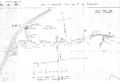
Map of Canning Wye and Spur as designed April 28, 1911.
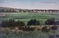
Postcard of Canning with the trestle of the Canning Wye and Spur postmarked Sept. 12, 1911.


References and Footnotes
Dan Conlin Field notes CVR Trip, April 20, 2008