Dominion Atlantic Railway Digital Preservation Initiative - Wiki
Use of this site is subject to our Terms & Conditions.
Difference between revisions of "Clementsport"
Dan conlin (talk | contribs) (→Gallery: image) |
Dan conlin (talk | contribs) (additional features) |
||
| Line 5: | Line 5: | ||
==Feature and Facilities== | ==Feature and Facilities== | ||
| − | *[[Clementsport | + | *[[Clementsport Station]], Mile 7.4 |
| − | *[[Clementsport | + | *Overhead timber bridge carrying public road, Mil 7.51 |
| − | + | *[[Clementsport Bridge]], over Moose River, Mile 7.67 | |
==Gallery== | ==Gallery== | ||
| Line 20: | Line 20: | ||
File:DAR - Clementsport Station End-Harold Jenkins Photo-July1959.JPG|[[Clementsport Station]], eastend with siding in foreground, July 1959. | File:DAR - Clementsport Station End-Harold Jenkins Photo-July1959.JPG|[[Clementsport Station]], eastend with siding in foreground, July 1959. | ||
</Gallery> | </Gallery> | ||
| + | |||
| + | ==References== | ||
| + | [[1969-MemoOfGenInfo|''Memorandum of General Information on the Dominion Atlantic Railway'', Feb. 17, 1969,]] page 15, Dominion Atlantic Railway, Library and Archives Canada HE2810 D7 D7 fol. | ||
| + | |||
[[Category:Locations]] | [[Category:Locations]] | ||
[[Category:Subdivision Yarmouth|Y074]] | [[Category:Subdivision Yarmouth|Y074]] | ||
Revision as of 12:44, 14 October 2018
Clementsport, Nova Scotia
- Subdivision Yarmouth, Mile 7.40
- Elevation unknown
- Passing track 1267' long (1969).
Feature and Facilities
- Clementsport Station, Mile 7.4
- Overhead timber bridge carrying public road, Mil 7.51
- Clementsport Bridge, over Moose River, Mile 7.67
Gallery
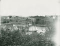
Clementsport and the Clementsport Bridge open for an inbound schooner, circa 1895.
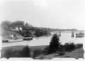
Clementsport Bridge and wharves, circa 1900.
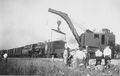
Locomotive No. 540; Boom Car No. 798 and Wreck Crane No. 802 with wreck of Train No. 98 near Clementsport, Aug. 2, 1944.
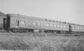
DAR coaches No. 625 and No. 23 part of Train No. 98 near Clementsport, Aug. 2, 1944.
Dining car "Blomidon" part of Train No. 98, derailed near Clementsport, Aug. 2, 1944.
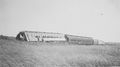
Train No. 98 near Clementsport, Aug. 2, 1944. L to R: unknown coach; coach No. 625; coach No. 23; unknown coach; diner "Blomidon" and a parlor/observation car.
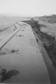
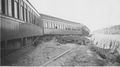
Roofs of Train No. 98 derailed near Clementsport, Aug. 2, 1944. Coaches include No. 625; No. 23.
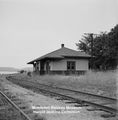
Clementsport Station, eastend with siding in foreground, July 1959.


References
Memorandum of General Information on the Dominion Atlantic Railway, Feb. 17, 1969, page 15, Dominion Atlantic Railway, Library and Archives Canada HE2810 D7 D7 fol.