Dominion Atlantic Railway Digital Preservation Initiative - Wiki
Use of this site is subject to our Terms & Conditions.
Difference between revisions of "Halfway River Bridge"
Dan conlin (talk | contribs) m |
Dan conlin (talk | contribs) m |
||
| Line 2: | Line 2: | ||
Mile 37.17 on the [[:Category:Subdivision Halifax|Halifax Subdivision]] | Mile 37.17 on the [[:Category:Subdivision Halifax|Halifax Subdivision]] | ||
| − | [[File:9365 HANTSPORT NS 1971-08 BILL | + | [[File:9365 HANTSPORT NS 1971-08 BILL LINLEYmedres.jpg|thumb|400px|right|DAR work crews repair the Hantsport Aboiteau, August 1971, photographed by Bill Linley.]] |
Located just east of [[Hantsport]], the bridge crossed the Halfway River (so named because in early times it marked the halfway point between [[Grand Pre]] and [[Windsor]]) where it meets the larger Avon River.<ref>[https://novascotia.ca/archives/places/page.asp?ID=278 C. Bruce Fergusson, "Hantsport"], ''Place-Names and Places of Nova Scotia'' Nova Scotia Archives (1967), p. 278.</ref> The Halfway River is small but had deep tidal estuary surrounded by wide tidal marshes where it is crossed by the DAR. | Located just east of [[Hantsport]], the bridge crossed the Halfway River (so named because in early times it marked the halfway point between [[Grand Pre]] and [[Windsor]]) where it meets the larger Avon River.<ref>[https://novascotia.ca/archives/places/page.asp?ID=278 C. Bruce Fergusson, "Hantsport"], ''Place-Names and Places of Nova Scotia'' Nova Scotia Archives (1967), p. 278.</ref> The Halfway River is small but had deep tidal estuary surrounded by wide tidal marshes where it is crossed by the DAR. | ||
| Line 16: | Line 16: | ||
Image:Halfway River Bridge construction.jpg|Construction work at the [[Halfway River Bridge]] in [[Hantsport]], with the town in the background, date unknown. | Image:Halfway River Bridge construction.jpg|Construction work at the [[Halfway River Bridge]] in [[Hantsport]], with the town in the background, date unknown. | ||
Image:Bluenose hantsport.jpg|Flying Bluenose at [[Hantsport]] crossing the [[Halfway River Bridge]], possibly with coach [[DAR000027|No. 27]] and baggage car [[DAR000046|No. 46]] circa 1920. | Image:Bluenose hantsport.jpg|Flying Bluenose at [[Hantsport]] crossing the [[Halfway River Bridge]], possibly with coach [[DAR000027|No. 27]] and baggage car [[DAR000046|No. 46]] circa 1920. | ||
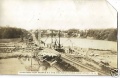
| − | File:9365 HANTSPORT NS 1971-08 BILL | + | File:9365 HANTSPORT NS 1971-08 BILL LINLEYmedres.jpg|[[CPR8133|No. 8133]] and ballast cars repairing washout at the [[Halfway River Bridge]] at [[Hantsport]], CKF paper plant in background, August 1971. |
File:Skelton1.jpg|[[Halfway River Bridge]] washout at [[Hantsport]] with DAR tracks hanging in midair over the eroding causeway over the former aboiteau, December 2017. | File:Skelton1.jpg|[[Halfway River Bridge]] washout at [[Hantsport]] with DAR tracks hanging in midair over the eroding causeway over the former aboiteau, December 2017. | ||
File:Skelton2.jpg|[[Halfway River Bridge]] washout at [[Hantsport]] with DAR tracks hanging over the former aboiteau and dyke remains, December 2017. | File:Skelton2.jpg|[[Halfway River Bridge]] washout at [[Hantsport]] with DAR tracks hanging over the former aboiteau and dyke remains, December 2017. | ||
Revision as of 14:23, 22 September 2018
Halfway River Bridge
Mile 37.17 on the Halifax Subdivision

Located just east of Hantsport, the bridge crossed the Halfway River (so named because in early times it marked the halfway point between Grand Pre and Windsor) where it meets the larger Avon River.[1] The Halfway River is small but had deep tidal estuary surrounded by wide tidal marshes where it is crossed by the DAR.
The bridge began in 1869 as a 150-foot long wooden truss bridge with a 640-foot long pile trestle approach on the east side (32 trestle spans, each each 20 feet long). A report by engineer Alexander MacNab in 1873 noted that the main span was weak and needed a pier in the middle and that many of the pile trestles were gradually being replaced by trestle bents.[2] The wooden bridge was replaced by a causeway with an aboiteau in 1879.[3]
By 1969, the bridge consisted of a 40-foot-long pile trestle over a spillway on the east side of a causeway at the Halfway River over an aboiteau with three 60-inch corrugated metal pipes.[4] DAR crews had to fill in a major washout at the Halfway River bridge in August 1971.[5]
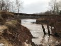
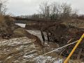
The railway ceased to be used in 2011. The causeway slowly began to erode and the aboiteau gates ceased functioning. Erosion increased dramatically in September 2017 and a large washout occurred in the causeway, leaving the rails hanging in mid-air and exposing the pile trestle work of older versions of the bridge.[6] The Windsor and Hantsport Railway put up barricades and removed the hanging rails on February 7, 2018,[7] but the washout grew leading to extensive tidal flooding of the formerly protected Halfway River Valley which raised fears about erosion and flooding of roads and power lines. The flooding has led to a dispute between the Province of Nova Scotia and the Windsor and Hantsport Railway over who owns the aboiteau and who bears the responsibility for the washout.[8]
Gallery
Construction work at the Halfway River Bridge in Hantsport, with the town in the background, date unknown.
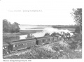
Flying Bluenose at Hantsport crossing the Halfway River Bridge, possibly with coach No. 27 and baggage car No. 46 circa 1920.

No. 8133 and ballast cars repairing washout at the Halfway River Bridge at Hantsport, CKF paper plant in background, August 1971.
Halfway River Bridge washout at Hantsport with DAR tracks hanging in midair over the eroding causeway over the former aboiteau, December 2017.
Halfway River Bridge washout at Hantsport with DAR tracks hanging over the former aboiteau and dyke remains, December 2017.
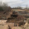
Halfway River Bridge washout at Hantsport, with collapsed aboiteau remnants of older bridge structure, April 28, 2018.
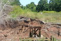
Halfway River Bridge looking west at Hantsport, close up of bridgework remains, Aug. 13, 2018
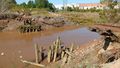
Halfway River Bridge washout at Hantsport and the bridge remains, August 13, 2018.
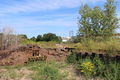
Halfway River Bridge at Hantsport, east side with wash out and piles from older bridges, with the CKF paper plant in background, Sept. 15, 2018.


References
- ↑ C. Bruce Fergusson, "Hantsport", Place-Names and Places of Nova Scotia Nova Scotia Archives (1967), p. 278.
- ↑ Windsor and Annapolis Railway, Report of Alexander MacNab, C. E., November 1, 1873, p. 7.
- ↑ Allen B. Robertson, Tide and Timber: Hantsport Nova Scotia 1795-1995, Lancelot Press, 1996, p. 71
- ↑ Memorandum of General Information on the Dominion Atlantic Railway, Feb. 17, 1969, page 4, Dominion Atlantic Railway, Library and Archives Canada HE2810 D7 D7 fol
- ↑ Bill Linley, Canadian Pacific in Color Volume 1: Eastern Lines, page 14.
- ↑ Carole Morris-Underhill, "Hantsport's Halfway River aboiteau failing, residents concerned about bridge integrity", Kings County Advertiser/Register, January 11, 2018.
- ↑ Carole Morris-Underhill, "Hantsport's failed aboiteau not only railway's problem to fix: owner, Kings County Advertiser/Register, February 9, 2018
- ↑ "LETTER: Railway owner weighs in on Hantsport aboiteau issue", The Register/Advertiser, Sept. 10, 2018