Dominion Atlantic Railway Digital Preservation Initiative - Wiki
Use of this site is subject to our Terms & Conditions.
Difference between revisions of "Kentville Railyard"
Dan conlin (talk | contribs) (images) |
Dan conlin (talk | contribs) |
||
| Line 22: | Line 22: | ||
Image:Kentville_Yard1.JPG|Title Block | Image:Kentville_Yard1.JPG|Title Block | ||
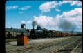
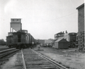
| − | Image:Dar2665a.jpg|[[DAR2665|No. 2665]] | + | Image:Dar2665a.jpg|[[DAR2665|No. 2665]] departs [[Kentville]] leading [[Train No. 95]] through the [[Kentville Railyard]]. Visible is [[Kentville Sanding Tower|sanding tower]] and the roof of the [[Kentville Machine Shop|Machine Shop]] store shed, August 1951. |
File:Kentville_Railyard_-_1958July.png|Kentville Railyard and [[P. R. Ritcey]] spur east of the Station, July 1958. | File:Kentville_Railyard_-_1958July.png|Kentville Railyard and [[P. R. Ritcey]] spur east of the Station, July 1958. | ||
Revision as of 20:36, 29 July 2017
Kentville Railyard


Railyard in sections
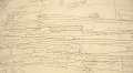
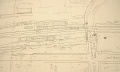
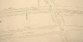
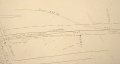
The above drawing is difficult to read but is proportionately correct and was scanned at 200 DPI. These images although not proportionally correct because they appeared photographed, not scanned, are the same map as above in sections and very readable with additional notes to explain some of the original notations on the map.
These images are just begging to be put on CAD. If anyone can help this way or advise what the proper way to set up a CAD file for land mapping is so others can do the tracing, please let us know. See this message thread on our forum: http://dardpi.ca/Forum/viewtopic.php?f=3&t=18#p49
Entire Map - low res. Same as above large map.
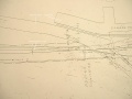
Section 1
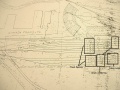
Section 2
Section 3
Section 4
Section 5
Section 6
Section 7
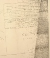
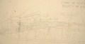
Title Block
No. 2665 departs Kentville leading Train No. 95 through the Kentville Railyard. Visible is sanding tower and the roof of the Machine Shop store shed, August 1951.
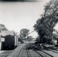
Kentville Railyard and P. R. Ritcey spur east of the Station, July 1958.
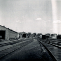
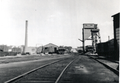
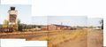
Kentville Railyard looking east from the base of the coal tower July 1958.
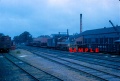
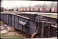
Kentville Railyard looking east showing the boiler plant, car shop, freight shed, coaling and sanding towers and machine shop, July 31, 1958.
CPR diesel No. 8135 passes through the Kentville Railyard along the the south side of the machine shop in 1961.
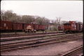
Kentville Railyard looking west with the coal tower on the left and the roundhouse in the very back and car shop to the right, 1967.
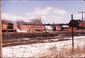
Kentville Railyard with Kentville Station to right, Feb. 14, 1976.
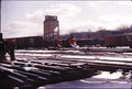
The Kentville Railyard with Coaling Tower and stored MOW equipment, circa Feb 1976.
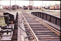
Kentville Turntable in front of Roundhouse with Kentville Railyard in background, May 5, 1976.
Looking out from the Kentville Turntable into the Kentville Railyard - 6th May 1976
Kentville Railyard, May 31, 1976.
Kentville Railyard composite photo with the Kentville Coaling Tower, Kentville Car Shop and the Kentville Repair Shop, October 1990.

.JPG)
.JPG)
.JPG)
.JPG)
.JPG)
.JPG)
.JPG)


