Dominion Atlantic Railway Digital Preservation Initiative - Wiki
Use of this site is subject to our Terms & Conditions.
Difference between revisions of "Horton Landing"
From DARwiki
Dan conlin (talk | contribs) (image) |
|||
| Line 3: | Line 3: | ||
*Next Station East: [[Avonport]] | *Next Station East: [[Avonport]] | ||
| − | *Next Station West: [[ | + | *Next Station West: [[Grand Pre]] |
==Facilities and Features== | ==Facilities and Features== | ||
| Line 13: | Line 13: | ||
<Gallery> | <Gallery> | ||
File:Wolfville 1905 Snowstorm a.jpg|Horton tracks and snow canyon during the famous winter of 1905. | File:Wolfville 1905 Snowstorm a.jpg|Horton tracks and snow canyon during the famous winter of 1905. | ||
| + | File:Gaspereaux River Bridge 1958.jpg|[[Gaspereaux River Bridge]] with the Horton Landing approach tracks looking eastward on July 31, 1958. | ||
File:Wolfville_21_H1_West.jpg|Topographic map from Kentville to Hortons Landing circa 1956. | File:Wolfville_21_H1_West.jpg|Topographic map from Kentville to Hortons Landing circa 1956. | ||
</Gallery> | </Gallery> | ||
Revision as of 16:26, 29 November 2013
Horton Landing, Nova Scotia
Mile 45.34 from Windsor Junction on the Halifax Subdivision (Mile 61.15 from Halifax)
Facilities and Features
- Horton Landing Station
- 1472 feet long Passing track in 1969
- Gaspereaux River Bridge
Gallery
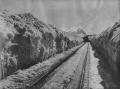
Horton tracks and snow canyon during the famous winter of 1905.
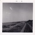
Gaspereaux River Bridge with the Horton Landing approach tracks looking eastward on July 31, 1958.
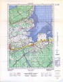
Topographic map from Kentville to Hortons Landing circa 1956.


