Dominion Atlantic Railway Digital Preservation Initiative - Wiki
Use of this site is subject to our Terms & Conditions.
Difference between revisions of "Aldershot"
From DARwiki
Dan conlin (talk | contribs) |
Dan conlin (talk | contribs) (image) |
||
| Line 20: | Line 20: | ||
<Gallery> | <Gallery> | ||
File:Berwick 21 H2 East.jpg|Topographic map from Berwick to Kentville circa 1956. | File:Berwick 21 H2 East.jpg|Topographic map from Berwick to Kentville circa 1956. | ||
| − | Image:Aldershot station.jpg|Camp Aldershot telegraph Station, 2008 | + | Image:Aldershot station June 1943.jpg|[[Aldershot Station]] in June of 1943. |
| + | Image:Aldershot station.jpg|Camp Aldershot telegraph Station, 2008. | ||
</Gallery> | </Gallery> | ||
Revision as of 13:16, 8 November 2013
Aldershot, Nova Scotia
Mile 1.6 from Kentville on the Kingsport Subdivision, the Cornwallis Valley Railway
Mile 1.6 from Kentville on the Spur Track D Kingsport after 1961
- Next Station North: Mill Village
- Next Station South: Kentville
Facilities
- Spur Irving Oil, Mile .55 (1930s)
- Aldershot Wye
- Camp Aldershot Military Station and telegraph office
Gallery
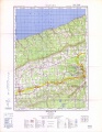
Topographic map from Berwick to Kentville circa 1956.
- Aldershot station June 1943.jpg
Aldershot Station in June of 1943.
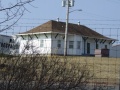
Camp Aldershot telegraph Station, 2008.


References and Footnotes
- Dominion Atlantic Railway Employee Time Table September 25, 1949, Library and Archives Canada, PMP - HE.2804 DC
- "Time Table No. 77 For Employees June 21, 1931", Dominion Atlantic Railway, p. 3