Dominion Atlantic Railway Digital Preservation Initiative - Wiki
Use of this site is subject to our Terms & Conditions.
Difference between revisions of "Hillaton"
From DARwiki
| Line 17: | Line 17: | ||
<Gallery> | <Gallery> | ||
File:Wolfville_21_H1_West.jpg|Topographic map from Kentville to Hortons Landing circa 1956. | File:Wolfville_21_H1_West.jpg|Topographic map from Kentville to Hortons Landing circa 1956. | ||
| + | File:100 1312.jpg | ||
| + | File:100 1314.jpg | ||
| + | File:100 1315.jpg | ||
| + | File:100 1318.jpg | ||
| + | File:100 1320.jpg | ||
| + | File:100 1321.jpg | ||
</Gallery> | </Gallery> | ||
Revision as of 23:16, 15 January 2013
Hillaton, Nova Scotia
Subdivision Kingsport, Mile 9.2
- Next Station East: Canning
- Next Station West: Sheffield Mills
Spur for cold storage plant, Mile 8.9
Flag Stop, Mile 9.2
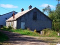
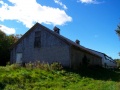
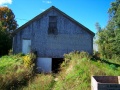
16 car siding with four fruit warehouses
Pile bridge over Habitant river, c. Mile 9.2
Gallery
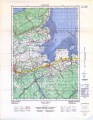
Topographic map from Kentville to Hortons Landing circa 1956.


References and Footnotes
- Dominion Atlantic Railway Employee Time Table September 25, 1949, Library and Archives Canada, pmp -HE.2804 DC