Dominion Atlantic Railway Digital Preservation Initiative - Wiki
Use of this site is subject to our Terms & Conditions.
Difference between revisions of "Mount Uniacke"
From DARwiki
Dan conlin (talk | contribs) m |
|||
| Line 12: | Line 12: | ||
==Gallery== | ==Gallery== | ||
<Gallery> | <Gallery> | ||
| + | File:Uniacke_11_D13.jpg|Topographic map from Stillwater to Windsor Junction circa 1956. | ||
Image:Mt. Uniacke Station 1961.jpg|[[Mount Uniacke Station]] in 1961. | Image:Mt. Uniacke Station 1961.jpg|[[Mount Uniacke Station]] in 1961. | ||
Image:Mount Uniacke 1958.jpg|Wayfreight from [[Windsor Junction]] to [[Kentville]] passes [[Mount Uniacke Water Tower]] on July 31, 1958. | Image:Mount Uniacke 1958.jpg|Wayfreight from [[Windsor Junction]] to [[Kentville]] passes [[Mount Uniacke Water Tower]] on July 31, 1958. | ||
</Gallery> | </Gallery> | ||
| + | |||
[[Category:Locations]] | [[Category:Locations]] | ||
[[Category:Subdivision Halifax|125]] | [[Category:Subdivision Halifax|125]] | ||
Revision as of 14:47, 13 January 2012
Mount Uniacke, Nova Scotia
Mile 12.8 from Windsor Junction on the Halifax Subdivision (Mile 28.51 from Halifax)
- Next Station East: South Uniacke
- Next Station West: Stillwater Lake
Facilities & Features
- Mount Uniacke Station
- Mount Uniacke Water Tower
- Passing Track 1738 feet in length
Gallery
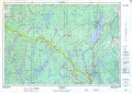
Topographic map from Stillwater to Windsor Junction circa 1956.
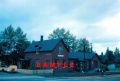
Mount Uniacke Station in 1961.
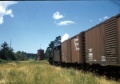
Wayfreight from Windsor Junction to Kentville passes Mount Uniacke Water Tower on July 31, 1958.


